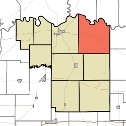
Jefferson Township, Pike County, Indiana
Appearance
Jefferson Township Pike County | |
|---|---|
 Location in Pike County | |
| Coordinates: 38°29′01″N 87°08′42″W / 38.48361°N 87.14500°W | |
| Country | |
| State | |
| County | Pike |
| Government | |
| • Type | Indiana township |
| Area | |
| • Total | 53.13 sq mi (137.6 km2) |
| • Land | 52.51 sq mi (136.0 km2) |
| • Water | 0.63 sq mi (1.6 km2) 1.19% |
| Elevation | 502 ft (153 m) |
| Population (2020) | |
| • Total | 1,797 |
| • Density | 34/sq mi (13/km2) |
| ZIP codes | 47564, 47567, 47590, 47598 |
| GNIS feature ID | 453495 |
Jefferson Township is one of nine townships in Pike County, Indiana, United States. As of the 2020 census, its population was 1,797 and it contained 813 housing units.[1]
| Census | Pop. | Note | %± |
|---|---|---|---|
| 1890 | 2,474 | — | |
| 1900 | 2,792 | 12.9% | |
| 1910 | 2,425 | −13.1% | |
| 1920 | 2,068 | −14.7% | |
| 1930 | 1,786 | −13.6% | |
| 1940 | 1,845 | 3.3% | |
| 1950 | 1,773 | −3.9% | |
| 1960 | 1,757 | −0.9% | |
| 1970 | 1,653 | −5.9% | |
| 1980 | 1,657 | 0.2% | |
| 1990 | 1,626 | −1.9% | |
| 2000 | 1,773 | 9.0% | |
| 2010 | 1,814 | 2.3% | |
| 2020 | 1,797 | −0.9% | |
| Source: US Decennial Census[2] | |||
Geography
[edit]According to the 2010 census, the township has a total area of 53.13 square miles (137.6 km2), of which 52.51 square miles (136.0 km2) (or 98.83%) is land and 0.63 square miles (1.6 km2) (or 1.19%) is water.[3] The White River defines the township's north border, as well as the north border of Pike County.
Unincorporated towns
[edit]- Algiers at 38°29′14″N 87°10′30″W / 38.487272°N 87.175009°W
- Cato at 38°26′12″N 87°11′08″W / 38.436717°N 87.185564°W
- Highbank Town at 38°30′52″N 87°09′01″W / 38.514494°N 87.150287°W
- Iva at 38°30′10″N 87°07′10″W / 38.502828°N 87.119452°W
- Otwell at 38°27′17″N 87°05′32″W / 38.454773°N 87.092228°W
(This list is based on USGS data and may include former settlements.)
Cemeteries
[edit]The township contains these eight cemeteries: Arnold, Bluff, Case, Chapel, Independent Order of Odd Fellows, Logan, McClure and Willis.
Major highways
[edit]School districts
[edit]- Pike County School Corporation
- Otwell Miller Academy, Public Charter School. Grades K-5
Political districts
[edit]- State House District 63
- State Senate District 48
References
[edit]- "Jefferson Township, Pike County, Indiana". Geographic Names Information System. United States Geological Survey, United States Department of the Interior. Retrieved November 26, 2009.
- United States Census Bureau 2009 TIGER/Line Shapefiles
- IndianaMap
- ^ "Explore Census Data". data.census.gov. Retrieved April 13, 2024.
- ^ "Township Census Counts: STATS Indiana".
- ^ "Population, Housing Units, Area, and Density: 2010 - County -- County Subdivision and Place -- 2010 Census Summary File 1". United States Census. Archived from the original on February 12, 2020. Retrieved May 10, 2013.

