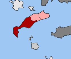
Irakleides
Appearance
Irakleides
Ηρακλείδες | |
|---|---|
| Coordinates: 36°49′N 27°06′E / 36.817°N 27.100°E | |
| Country | Greece |
| Administrative region | South Aegean |
| Regional unit | Kos |
| Municipality | Kos |
| Area | |
| • Municipal unit | 160.5 km2 (62.0 sq mi) |
| Population (2021)[1] | |
| • Municipal unit | 7,467 |
| • Municipal unit density | 47/km2 (120/sq mi) |
| Time zone | UTC+2 (EET) |
| • Summer (DST) | UTC+3 (EEST) |
Irakleides (Greek: Ηρακλείδες) is a former municipality on the island of Kos, in the Dodecanese, Greece. Since the 2011 local government reform, it is part of the municipality Kos, of which it is a municipal unit.[2] Population 7,467 (2021). It is the largest in area of the three municipal units on the island, at 160.538 km²,[3] and comprises 55.3% of the island's territory. The seat of the municipality was in Antimacheia. The largest village is Kefalos. Kardamaina, Mastichari, Kampos, Onia, and Kamarion are the other villages in the municipal unit. It shares the island of Kos with the municipal units of Kos and Dikaios.
References
[edit]- ^ "Αποτελέσματα Απογραφής Πληθυσμού - Κατοικιών 2021, Μόνιμος Πληθυσμός κατά οικισμό" [Results of the 2021 Population - Housing Census, Permanent population by settlement] (in Greek). Hellenic Statistical Authority. 29 March 2024.
- ^ "ΦΕΚ B 1292/2010, Kallikratis reform municipalities" (in Greek). Government Gazette.
- ^ "Population & housing census 2001 (incl. area and average elevation)" (PDF) (in Greek). National Statistical Service of Greece. Archived from the original (PDF) on 2015-09-21.


