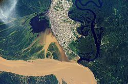
Iquitos metropolitan area
Appearance
Iquitos metropolitan area | |
|---|---|
 | |
 | |
| Country | Peru |
| Region | Loreto |
| Province | Maynas |
| Largest city | Iquitos |
| Population (2007 Census) | |
| • Total | 406.340(year 2,007) 471.993(year 2,015) |
| Time zone | UTC-5 (PET) |
The Iquitos Metropolitan Area is the name used to refer to the Peruvian metropolitan area whose principal city is Iquitos, according to Municipality of Iquitos. According to population statistics of INEI It is the sixth most populous metropolitan area of Peru in year 2015.
Metropolitan districts
[edit]According to studies of municipality of Maynas Iquitos metropolitan area consist in four districts: Iquitos, Belén, Punchana and San Juan Bautista.[1] The estimated population of INEI for the metropolitan districts in year 2015 is shown in the following table.
| Metropolitan Districts |
Area km² |
Houses (2007) |
Density (pop./km²)* |
Elevation media msl* |
Distance to Iquitos (km) |
Population Census 2007 |
Population 2015[2] |
|---|---|---|---|---|---|---|---|
| Iquitos. | 358,15 | 32.853 | 444,01 | 106 m.s.n.m. | 0 km | 159.023* | 150.484 |
| Belén. | 632,8 | 13.581 | 108,73 | 110 m.s.n.m. | 68.806* | 75.685 | |
| Punchana. | 1.573,39 | 15.261 | 48,58 | 105 m.s.n.m. | 76.435* | 91.128 | |
| San Juan Bautista. | 3.117,05 | 23.981 | 32,75 | 138 m.s.n.m. | 102.076* | 154.696 | |
| Total | 5.681,39 km2 | 85.676 | 71,52 | — | — | 406.340* | 471.993 |
| Sources:Census 2007,[3] Estimated Population 2015[2] | |||||||
See also
[edit]References
[edit]- ^ Maynas Municipality (ed.). "Ubicación Geográfica".
- ^ a b "Perú:Estimaciones y proyecciones de Población Por sexo según Departamento, Provincia y Distrito 2012–2015 – INEI".
- ^ "Censos Nacionales 2007 de Población y Vivienda". 2008. Archived from the original on 7 September 2013.
