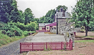
Ilderton railway station
Appearance
Ilderton | |
|---|---|
 The site of the station in 2000 | |
| General information | |
| Location | Ilderton, Northumberland England |
| Coordinates | 55°30′22″N 1°58′16″W / 55.5062°N 1.9711°W |
| Grid reference | NU019236 |
| Platforms | 1 |
| Other information | |
| Status | Disused |
| History | |
| Original company | North Eastern Railway |
| Post-grouping | LNER |
| Key dates | |
| 5 September 1887 | Opened |
| 22 September 1930 | Closed to passengers |
| 2 March 1953 | Closed completely |
Ilderton railway station served the village of Ilderton, Northumberland, England from 1887 to 1953 on the Cornhill Branch.
History
[edit]The station opened on 5 September 1887 by the North Eastern Railway. It was situated on the west side of the A697. There were a wide range of buildings (as well as the station building), namely a stone warehouse, coal and lime drops, an office and livestock loading facilities. As well as having these facilities, there were five sidings, one serving the goods shed and three serving a goods platform. In 1911, the station sold 4,279 tickets with the population of the local village being 1,252. The station closed to passengers on 22 September 1930[1] and to goods traffic on 2 March 1953.[2]
References
[edit]- ^ Quick, M E (2002). Railway passenger stations in England, Scotland and Wales - a chronology. Richmond: Railway and Canal Historical Society. p. 238. OCLC 931112387.
- ^ "Disused Stations: Ilderton". Disused Stations. Retrieved 7 March 2018.
External links
[edit]| Preceding station | Disused railways | Following station | ||
|---|---|---|---|---|
| Wooler Line and station closed |
North Eastern Railway Cornhill Branch |
Wooperton Line and station closed |
