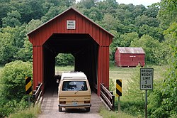
Hune Covered Bridge
Hune Covered Bridge | |
 A vehicle crossing the bridge | |
| Location | State Route 26 in Lawrence Township, Washington County |
|---|---|
| Nearest city | Dart, Ohio |
| Coordinates | 39°30′38″N 81°15′2″W / 39.51056°N 81.25056°W |
| Area | less than one acre |
| Built | 1879 |
| Architect | Rollin Meredith |
| Architectural style | Long truss |
| NRHP reference No. | 76001545[1] |
| Added to NRHP | October 8, 1976 |
The Hune Covered Bridge is a historic wooden covered bridge in the southeastern part of the U.S. state of Ohio. Located northeast of the community of Dart,[1] it spans the Little Muskingum River in northeastern Lawrence Township in the eastern part of Washington County.[2] Local bridge builder Rollin Meredith erected it in 1879,[1] using the Long-truss style of truss bridge design; the single-span bridge was named for the locally prominent Hune family. Among its design features are a metal roof, abutments of cut stone, and vertical siding. As a Long truss, the Hune Bridge is a valuable example of nineteenth-century architecture: few examples of this complicated style survive to the present day.[3] In 1976, the Hune Bridge was listed on the National Register of Historic Places, both because of its place in local history and because of its historically significant construction.[1]
References
[edit]- ^ a b c d "National Register Information System". National Register of Historic Places. National Park Service. March 13, 2009.
- ^ DeLorme. Ohio Atlas & Gazetteer. 7th ed. Yarmouth: DeLorme, 2004, 72-73. ISBN 0-89933-281-1.
- ^ Owen, Lorrie K., ed. Dictionary of Ohio Historic Places. Vol. 2. St. Clair Shores: Somerset, 1999, 1394.
External links
[edit]![]() Media related to Hune Covered Bridge at Wikimedia Commons
Media related to Hune Covered Bridge at Wikimedia Commons
- Bridges completed in 1879
- Covered bridges on the National Register of Historic Places in Ohio
- Bridges in Washington County, Ohio
- National Register of Historic Places in Washington County, Ohio
- Wooden bridges in Ohio
- Tourist attractions in Washington County, Ohio
- Road bridges on the National Register of Historic Places in Ohio
- Long truss bridges in the United States
- 1879 establishments in Ohio
- Appalachian Ohio Registered Historic Place stubs
- Midwestern United States bridge (structure) stubs
- Ohio building and structure stubs
- Ohio transportation stubs


