Hortsavinyà
Appearance
Hortsavinyà | |
|---|---|
Village | |
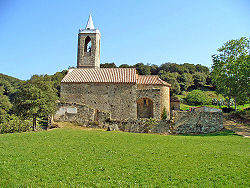
 Church of Santa Eulàlia (or Sant Llop) in Hortsavinyà | |
| Coordinates: 41°40′04″N 2°37′43″E / 41.66778°N 2.62861°E | |
| Country | Spain |
| Autonomous community | Catalonia |
| Province | Barcelona |
| Comarca | Maresme |
| Municipality | Tordera |
| Elevation | 490 m (1,610 ft) |
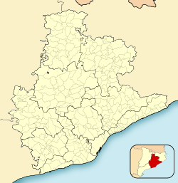
Hortsavinyà is a village within the municipality of Tordera in the comarca of Maresme, province of Barcelona, Catalonia, Spain.[1]
The GR 92 long distance footpath, which roughly follows the length of the Mediterranean coast of Spain, has a staging point at Hortsavinyà. Stage 13 links northwards to Tordera, a distance of 12.8 kilometres (8.0 mi), whilst stage 14 links southwards to Vallgorguina, a distance of 17.4 kilometres (10.8 mi).[2]
References
[edit]- ^ Vissir3 (Map). Institut Cartogràfic i Geològic de Catalunya. Retrieved 18 November 2022.
- ^ "GR 92: Sender de la Mediterrània" [GR 92: Mediterranean Path]. www.catalunya.com (in Catalan). Archived from the original on 7 November 2022. Retrieved 7 November 2022.


