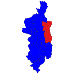
Hopong Township
Appearance
This article needs additional citations for verification. (August 2024) |
This article contains promotional content. (August 2024) |
Hopong Township
ဟိုပုန်းမြို့နယ် ဝေင်ꩻနယ်ႏဟိုပုံꩻ | |
|---|---|
 Location in Taunggyi district | |
| Coordinates: 20°47′N 97°11′E / 20.783°N 97.183°E | |
| Country | |
| State | Shan State |
| District | Taunggyi District |
| Capital | Hopong |
| Area | |
• Total | 2,922 km2 (1,128 sq mi) |
| Population (2014) | |
• Total | 112,348 |
| • Density | 38/km2 (100/sq mi) |
| Time zone | UTC+6:30 (MST) |
Hopong Township (Burmese: ဟိုပုန်းမြို့နယ်) (Pa'o Karen: ဝေင်ꩻနယ်ႏဟိုပုံꩻ) is a township of Taunggyi District in the Shan State of Myanmar. The principal town is Hopong, Pa'O Self-Administered Zone.
Hopong has numerous tourist destinations, such as Htam Sam Cave[1] and Mway Taw Pagoda. Many visitors from different parts of the country enjoy going to Htam Sam Cave, which is not only a beauty spot for nature lovers, but also a place with numerous Buddha images which attract many Buddhist pilgrimages. Near the cave, moreover, free delicious vegetarian meal is served which is well worth enjoying. Mway Taw Pagoda is an impressive pagoda in the centre of the town which is the most significant religious site in Hopong.
References
[edit]- ^ "Show Caves of Myanmar: Htan San Cave". Show Caves of the World. Retrieved 2024-08-05.


