Holobutiv
Appearance
Holobutiv
Голобутів | |
|---|---|
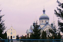
 Church Ascension of the Lord. Holobutiv | |
| Coordinates: 49°15′36″N 23°44′14″E / 49.26000°N 23.73722°E | |
| Country | |
| Province | |
| District | |
| Established | 1664 |
| Area | |
• Total | 1,768 km2 (683 sq mi) |
| Elevation /(average value of) | 305 m (1,001 ft) |
| Population | |
• Total | 937 |
| • Density | 53/km2 (140/sq mi) |
| Time zone | UTC+2 (EET) |
| • Summer (DST) | UTC+3 (EEST) |
| Postal code | 82433 |
| Area code | +380 3245 |
| Website | село Голобутів (Ukrainian) |
Holobutiv (Ukrainian: Голобу́тів) – village (selo) is located in Stryi Raion, Lviv Oblast, of Western Ukraine. It belongs to Stryi urban hromada, one of the hromadas of Ukraine.[1] The population of the village is 937, and the local government is administered by the Holobutivska village council.[2]
The village is located to the side of the Stryi Road and Drohobych at a distance 10 kilometres (6.2 mi) from the district center Stryi, 80 kilometres (50 mi) from the regional center Lviv and 25 kilometres (16 mi) from Drohobych.
The first record of the village dates back to the year 1664.[3]
References
[edit]- ^ "Стрыйская городская громада" (in Russian). Портал об'єднаних громад України.
- ^ "Holobutivska village council". Archived from the original on 2015-01-17. Retrieved 2015-01-13.
- ^ Holobutiv village: street map, photos
External links
[edit]


