Hjelmeland og Fister
Hjelmeland og Fister Municipality
Hjelmeland og Fister herred | |
|---|---|
 Rogaland within Norway | |
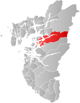
 Hjelmeland og Fister within Rogaland | |
| Coordinates: 59°14′12″N 06°10′44″E / 59.23667°N 6.17889°E | |
| Country | Norway |
| County | Rogaland |
| District | Ryfylke |
| Established | 1 Jan 1859 |
| • Preceded by | Hjelmeland Municipality |
| Disestablished | 1 July 1884 |
| • Succeeded by | Hjelmeland and Fister municipalities |
| Administrative centre | Hjelmelandsvågen |
| Area (upon dissolution) | |
| • Total | 577.6 km2 (223.0 sq mi) |
| Population (1884) | |
| • Total | 2,249 |
| • Density | 3.9/km2 (10/sq mi) |
| Demonym | Hjelmelandsbu[1] |
| Time zone | UTC+01:00 (CET) |
| • Summer (DST) | UTC+02:00 (CEST) |
| ISO 3166 code | NO-1133[2] |
Hjelmeland og Fister is a former municipality in Rogaland county, Norway. The 577-square-kilometre (223 sq mi) municipality[3][4] existed from 1859 until its dissolution in 1884. It encompassed the area of today's Hjelmeland municipality plus the eastern islands in today's Stavanger municipality. The administrative centre of the municipality was the village of Hjelmelandsvågen. There were two churches in the municipality: Fister Church and Hjelmeland Church.
History
[edit]The municipality of Hjelmeland og Fister was established in 1859 when the old municipality of Hjelmeland was split into Årdal and Hjelmeland og Fister. Initially, Hjelmeland og Fister had 3,084 residents. On 6 March 1869, a small area of Årdal municipality (population: 40) was transferred to Hjelmeland og Fister. The municipality was split into two on 1 July 1884. The Fister islands and the land surrounding the Fisterfjorden (population: 832) became the new municipality of Fister with a total of 42.56 square kilometres (16.43 sq mi) of land.[4] The rest of the municipality (population: 2,249) became the new municipality of Hjelmeland with 535 square kilometres (207 sq mi) of land.[3][5]
Name
[edit]The municipal name is a combination of the names of two areas that make up the municipality, literally meaning "Hjelmeland and Fister". The first part is named after the old Hjelmeland farm (Old Norse: Hjalmaland) since the first Hjelmeland Church was built there. Today the farm is a part of the Hjelmelandsvågen urban area. The first element of the name is the plural genitive case of hjalmr which means "helmet" (likely referring to two hills behind the farm which have the form of two helmets). The last element is land which means "land" or "farm".[6]
The second part is named after the old Fister farm (Old Norse: Fístr) since the first Fister Church was built there. The name probably comes from the word fístr which means "windy" or "hardy". It is probably related to the verb fise which means "to pass gas".[7]
See also
[edit]References
[edit]- ^ "Navn på steder og personer: Innbyggjarnamn" (in Norwegian). Språkrådet.
- ^ Bolstad, Erik; Thorsnæs, Geir, eds. (26 January 2023). "Kommunenummer". Store norske leksikon (in Norwegian). Kunnskapsforlaget.
- ^ a b Helland, Amund (1888). "Hjelmeland herred". XI Stavanger amt. Norges land og folk (in Norwegian). Kristiania, Norway: H. Aschehoug & Company. p. 361. Retrieved 3 July 2022.
- ^ a b Helland, Amund (1888). "Fister herred". XI Stavanger amt. Norges land og folk (in Norwegian). Kristiania, Norway: H. Aschehoug & Company. p. 354. Retrieved 3 July 2022.
- ^ Jukvam, Dag (1999). Historisk oversikt over endringer i kommune- og fylkesinndelingen (PDF) (in Norwegian). Statistisk sentralbyrå. ISBN 9788253746845.
- ^ Rygh, Oluf (1915). Norske gaardnavne: Stavanger amt (in Norwegian) (10 ed.). Kristiania, Norge: W. C. Fabritius & sønners bogtrikkeri. pp. 321 and 329.
- ^ Rygh, Oluf (1915). Norske gaardnavne: Stavanger amt (in Norwegian) (10 ed.). Kristiania, Norge: W. C. Fabritius & sønners bogtrikkeri. pp. 309–310.

