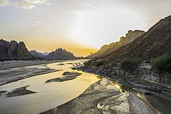
Hingol River
Appearance
| Hingol River | |
|---|---|
 | |
 | |
| Native name | دریائے ہنگول (Urdu) |
| Location | |
| Country | Pakistan |
| Province | Balochistan |
| Districts | Awaran District, Gwadar District |
| Physical characteristics | |
| Mouth | |
• coordinates | 25°22′50″N 65°30′55″E / 25.38056°N 65.51528°E |
• elevation | 0 m (0 ft) |
| Length | 560 km (350 mi)[2] |
| Basin size | 34,557.6 km2 (13,342.8 sq mi)[1] |
| Discharge | |
| • location | Near mouth |
| • average | (Period: 1971–2000)71.9 m3/s (2,540 cu ft/s)[1] |
| Basin features | |
| Progression | Arabian Sea |
| River system | Hingol River |
Hingol River or Hungol River (Urdu: دریائے ہنگول) is located in the Makran region, in the Gwadar District of southeastern Balochistan Province, in southwestern Pakistan. The river and valley are protected within Hingol National Park.[2]
Geography
[edit]The Hingol River is 560 km (350 mi) long, the longest in Balochistan.[2] It winds through the Makran Coastal Range and Hungol Valley between high cliffs.[2]
The river flows all year long, unlike most other streams in Balochistan which only flow during rare rains.[2]
Fauna
[edit]According to WWF-Pakistan, the Hingol is one of Balochistan’s four coastal rivers, including the Kech, Hub and Basol rivers, that hosts a healthy crocodile population.[3]
See also
[edit]References
[edit]- ^ a b "Arabian Sea Coast".
- ^ a b c d e "Hingol National Park". Pakistan Paedia: National Parks. JalalsPages. 12 September 2006. Retrieved 2008-10-15.
- ^ Agency, Anadolu (2024-05-16). "Pakistan's marsh crocodiles falling prey to climate ravages". The Express Tribune. Retrieved 2024-07-02.
Wikimedia Commons has media related to Hingol River.
