Hillersleben
Appearance
Hillersleben | |
|---|---|
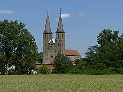
 St. Laurentius Church of the former Benedictine nuns monastery in Hillersleben | |
| Coordinates: 52°16′N 11°29′E / 52.267°N 11.483°E | |
| Country | Germany |
| State | Saxony-Anhalt |
| District | Börde |
| Municipality | Westheide |
| Area | |
• Total | 15.25 km2 (5.89 sq mi) |
| Elevation | 48 m (157 ft) |
| Population (2006-12-31) | |
• Total | 844 |
| • Density | 55/km2 (140/sq mi) |
| Time zone | UTC+01:00 (CET) |
| • Summer (DST) | UTC+02:00 (CEST) |
| Postal codes | 39343 |
| Dialling codes | 039202, 03904 |
| Vehicle registration | BK |
Hillersleben is a village and a former municipality in the Börde district in Saxony-Anhalt, Germany. A large proving ground for artillery operated there from 1934 to 1945.[1] Since 1 January 2010, it is part of the municipality Westheide.
References
[edit]- ^ "Rüstungstagung In Hillersleben | PanzerPlace". PanzerPlace. Retrieved 2021-12-04.


