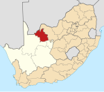
Heuningvlei
Appearance
Heuningvlei
Tsoe Coe | |
|---|---|
| Coordinates: 26°17′28″S 23°10′55″E / 26.291°S 23.182°E | |
| Country | South Africa |
| Province | Northern Cape |
| District | John Taolo Gaetsewe |
| Municipality | Joe Morolong |
| Area | |
• Total | 7.90 km2 (3.05 sq mi) |
| Population (2011)[1] | |
• Total | 2,656 |
| • Density | 340/km2 (870/sq mi) |
| Racial makeup (2011) | |
| • Black African | 98.9% |
| • Coloured | 0.3% |
| • Indian/Asian | 0.6% |
| • White | 0.2% |
| • Other | 0.1% |
| First languages (2011) | |
| • Tswana | 92.8% |
| • S. Ndebele | 2.3% |
| • English | 1.6% |
| • Other | 3.2% |
| Time zone | UTC+2 (SAST) |
| Postal code (street) | 8611 |
| Area code | 05492 |
Heuningvlei is a village in Joe Morolong Local Municipality in the Northern Cape province of South Africa. The name means "the hollow of the bees where water gathers".[2]
Heuningvlei was formerly owned by Turner & Newall.[2] Blue asbestos was mined at Heuningvlei until 1979, and many local residents suffer from asbestos-related diseases.[3]
References
[edit]- ^ a b c d "Main Place Heuningvlei". Census 2011.
- ^ a b "Multinational Asbestos Miners Have Left a Trail of Deadly Fiber and Dying Workers in South Africa". Multinational Monitor, March 1982. Retrieved 26 July 2014.
- ^ "Heuningvlei Asbestos Interest Group". Health Systems Trust. Archived from the original on 12 August 2014. Retrieved 26 July 2014.


