Hennset
Appearance
Hennset
Hendset | |
|---|---|
Village | |
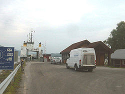
 The ferry dock in Hennset | |
Location in Trøndelag | |
| Coordinates: 63°8′9.2″N 08°26′12.5″E / 63.135889°N 8.436806°E | |
| Country | Norway |
| Region | Western Norway |
| County | Trøndelag |
| Municipality | Heim |
| Elevation | 23 m (75 ft) |
| Time zone | UTC+01:00 (CET) |
| • Summer (DST) | UTC+02:00 (CEST) |
| Post Code | 6687 Valsøyfjord |
Hennset or Hendset is a village and ferry point in the municipality of Heim in Trøndelag county, Norway. It lies along Arasvik Fjord between the villages of Liabøen and Valsøyfjord next to European route E39. The ferry connects the village to Arasvika in the municipality of Aure and County Road 682.[2]
References
[edit]- ^ "Hennset, Halsa (Trøndelag)" (in Norwegian). yr.no. Retrieved March 4, 2017.
- ^ Norgeskart: Hennset and Arasvika.


