Haverford College, Pennsylvania
Appearance
Haverford College (CDP), Pennsylvania | |
|---|---|
 Founders Hall | |
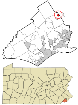
 Location in Delaware County and the state of Pennsylvania | |
| Coordinates: 40°00′29″N 75°18′23″W / 40.00806°N 75.30639°W | |
| Country | United States |
| State | Pennsylvania |
| Counties | Delaware, Montgomery |
| Townships | Haverford, Lower Merion |
| Area | |
| • Total | 0.31 sq mi (0.80 km2) |
| • Land | 0.30 sq mi (0.79 km2) |
| • Water | 0.00 sq mi (0.01 km2) |
| Elevation | 351 ft (107 m) |
| Population | |
| • Total | 1,497 |
| • Density | 4,924.34/sq mi (1,900.98/km2) |
| Time zone | UTC-5 (Eastern (EST)) |
| • Summer (DST) | UTC-4 (EDT) |
| FIPS code | 42-33154 |
| GNIS feature ID | 2633706 |
Haverford College (CDP) is a census-designated place[3] located in Haverford Township, Delaware County, and Lower Merion Township, Montgomery County, in the U.S. state of Pennsylvania. It corresponds to the campus of Haverford College, located on the southwestern side of U.S. Route 30, approximately 10 miles (16 km) northwest of the city of Philadelphia. As of the 2010 census, the population was 1,331.[4]
Demographics
[edit]| Census | Pop. | Note | %± |
|---|---|---|---|
| 2020 | 1,497 | — | |
| U.S. Decennial Census[5] | |||
References
[edit]- ^ "ArcGIS REST Services Directory". United States Census Bureau. Retrieved October 12, 2022.
- ^ "Census Population API". United States Census Bureau. Retrieved October 12, 2022.
- ^ Promotions, Center for New Media and. "US Census Bureau 2010 Census".
- ^ "U.S. Census website". United States Census Bureau. Retrieved May 14, 2011.
- ^ "Census of Population and Housing". Census.gov. Retrieved June 4, 2016.
External links
[edit]


