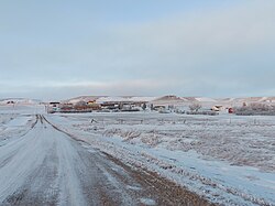
Hanks, North Dakota
Appearance
Hanks | |
|---|---|
 Hanks, North Dakota | |
| Coordinates: 48°36′12″N 103°48′11″W / 48.60333°N 103.80306°W | |
| Country | United States |
| State | North Dakota |
| County | Williams |
| Elevation | 2,116 ft (645 m) |
| Time zone | UTC-6 (Central (CST)) |
| • Summer (DST) | UTC-5 (CDT) |
| Area code | 701 |
| GNIS feature ID | 1029297[1] |
Hanks is an unincorporated community in Williams County, North Dakota, United States.
Geography
[edit]Hanks is located on North Dakota Highway 50, and has the latitude of 48.603° N, and the longitude of −103.802° W. The elevation is 2,116 feet (645 m), and is located in the Central Time Zone.
History
[edit]Hanks was founded in 1916 along a Great Northern Railway branch line that ran from Stanley to Grenora. The name honors W.F. Hanks, a banker from Powers Lake.[2]
Hanks disincorporated in 1992.[3]
According to a 2008 report, Hanks had only one inhabitant.[4] The town was included in the National Geographic article The Emptied Prairie, published in January 2008.[5]
| Census | Pop. | Note | %± |
|---|---|---|---|
| 1930 | 213 | — | |
| 1940 | 192 | −9.9% | |
| 1950 | 115 | −40.1% | |
| 1960 | 78 | −32.2% | |
| 1970 | 13 | −83.3% | |
| 1980 | 10 | −23.1% | |
| 1990 | 11 | 10.0% | |
| U.S. Decennial Census | |||
Notable people
[edit]- A. R. Shaw, educator and legislator[6]
References
[edit]- ^ a b U.S. Geological Survey Geographic Names Information System: Hanks, North Dakota
- ^ Wick, Douglas A. "Hanks (Williams County)". North Dakota Place Names. Archived from the original on January 12, 2012. Retrieved May 8, 2011.
- ^ "Boundary Changes".
- ^ Rubin, Richard (April 9, 2006). "Not far from forsaken". The New York Times. Retrieved October 25, 2015.
- ^ Bowden, Charles (January 2008). "The Emptied Prairie". National Geographic. Archived from the original on February 16, 2008. Retrieved May 8, 2011.
- ^ 'North Dakota Centennial Blue Book 1889-1989, Ben Meier (editor), North Dakota Legislative Assembly, Biosgraphical Sketch of Arch Shaw, pg. 411


