Hammam Righa
Appearance
Hammam Righa | |
|---|---|
 | |
| Nickname: ⵃⴻⵎⵎⴰⵎ ⵔⵉⵖⴰ | |
 | |
| Country | Algeria |
| Province | Aïn Defla |
| Population (2008[1]) | |
| • Total | 8,488 |
| Time zone | UTC+1 (West Africa Time) |
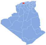
Hammam Righa (حمام ريغة) (ⵃⴻⵎⵎⴰⵎ ⵔⵉⵖⴰ) is a town in northern Algeria. During the period of Roman occupation, Hammam Righa was a Roman colony called Aquae Calidae.[2] It is located at 36.379474n, 2.395618e near the railway town of Boumedfaa,[3] and is on the Oued Djer River.[4] The population in 2008 was 8488.[5] and the population density is 369 persons/km².

Maurice Audin (1932-1957), mathematician, lived here from 1943 to 1946.[6]
References
[edit]- ^ "Wilaya d'Aïn Defla : répartition de la population résidente des ménages ordinaires et collectifs, selon la commune de résidence et la dispersion" (PDF).. Données du recensement général de la population et de l'habitat de 2008 sur le site de l'ONS.
- ^ Dictionary of Greek and Roman Geography
- ^ Barrington Atlas p30 D4 Aquae Calidae.
- ^ Aquae Calidae (Hammam Righa)
- ^ Wilaya d'Aïn Defla : répartition de la population résidente des ménages ordinaires et collectifs, selon la commune de résidence et la dispersion Données du recensement général de la population et de l'habitat de 2008 sur le site de l'ONS.
- ^ Michèle Audin, Une vie brève, Paris, Gallimard, 2013, pp. 49-56.
36°23′N 2°24′E / 36.383°N 2.400°E

