Haltonville, Ontario
Haltonville | |
|---|---|
Unincorporated community | |
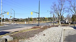
 Looking north on Guelph Line at the "four corners" in Haltonville | |
| Coordinates: 43°31′33″N 80°02′12″W / 43.52583°N 80.03667°W | |
| Country | Canada |
| Province | Ontario |
| Regional municipality | Halton |
| Town | Milton |
| Time zone | UTC-5 (Eastern (EST)) |
| • Summer (DST) | UTC-4 (EDT) |
| GNBC Code | FBLIH[1] |
Haltonville is an unincorporated community in Milton, Ontario, Canada.[1]
Once a thriving pioneer community, little remains of the original settlement.
History
[edit]
The early settlement was first named "Sodom", while Moffat, located 2.8 km (1.7 mi) west, was named "Gomorrah". This was in reference to the immoral Biblical cities of Sodom and Gomorrah, because between 1850 and 1888, the road between these two settlements "was not safe to travel upon after dark. There were drinking houses on all corners".[3][4]
The first building in Haltonville was Nassagaweya Presbyterian Church, erected in 1839. The church had 45 members by 1854. A cemetery was established in 1866, and the wood-frame building was replaced by a stone church in 1861. The church was designated a historic property by the Town of Milton in 2004.[5][6]
Haltonville was settled in 1845 when George Black built a home and shoemaker shop.[7] In 1846, a general store and blacksmith shop were built, and in 1850, the Bee Hive Hotel was built. The first doctor settled in Haltonville in 1852, and in 1859 a second hotel was built.[3][8] The early settlement also had an apiary, creamery, and money order and savings bank office.[7][9][10]
In 1885, the first shorthorn cattle in the Nassagaweya Township were introduced by Haltonville farmer William Dredge Sr.[3] That same year, the settlement had a population of 100.[11]
Haltonville was the birthplace of Lititea Meade, who was one of just 18 female doctors in Ontario when she graduated medical school in 1891.[8]
References
[edit]- ^ a b "Haltonville". Natural Resources Canada. October 6, 2016.
- ^ "Heritage Master Plan by the Volunteer Ad Hoc Task Force" (PDF). Town of Milton. October 24, 2016.
- ^ a b c "Once Called Sodom, Now a Cross-Roads Hamlet" (PDF). The Canadian Champion. December 11, 1974.
- ^ "Metropolitan Areas - Milton". Statistics Canada. May 20, 2016.
- ^ "Heritage Designation". Town of Milton. Retrieved March 25, 2017.
- ^ "Nassagaweya Presbyterian Church & Cemetery". Ontario Genealogical Society - Halton-Peel Branch. Retrieved March 25, 2017.
- ^ a b "Milton Town Hall Heritage: History Meets Modern Day" (PDF). Town of Milton. Archived from the original (PDF) on March 27, 2017. Retrieved March 25, 2017.
- ^ a b Mullen, Bonnie (May 2000). "Haltonville's Female Doctor - Dr. Lititea Meade-Sirrs" (PDF). The Compass.
- ^ White, William (1872). Post Office Gazetteer of the Dominion of Canada. Post Office Department of Canada. p. 57.
- ^ Annual Report of the Department of Agriculture and Food. Vol. 2. The Legislative Assembly of Ontario. 1896. p. 100.
- ^ The Gazetteer of the World. Vol. IV. Thomas C. Jack. 1885. p. 114.


