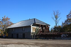
Hüüru
Appearance
Hüüru | |
|---|---|
 Hüüru watermill | |
| Coordinates: 59°22′49″N 24°32′23″E / 59.38028°N 24.53972°E | |
| Country | Estonia |
| County | Harju County |
| Municipality | Saue Parish |
| First mentioned | 1241[1] |
| Population (01.01.2012[2]) | |
• Total | 417 |
Hüüru is a village in Saue Parish, Harju County in northern Estonia.[3] It's located 3 km (1.9 mi) west of the border of Tallinn (and about 13 km (8 mi) from the city centre), on the crossing of Tallinn–Paldiski road (E265) and Vääna River, just next to Harku. Hüüru has a population of 417 (as of 1 January 2012).[2]
Hüüru was first mentioned in the Danish Census Book in 1241 as Hiurenkylae. In 1560 the Hüüru Manor (Hüer) was established on the site of the Harku Manor's watermill. The watermill had existed already in 1540–50.[1] The main building of the manor was built in partially in the 18th and 19th centuries.[4] Nowadays it is used as a local library. The watermill is situated just by the road houses.
Gallery
[edit]-
Hüüru Manor. Now the servce point for Saue libraries and the Hüüru Village Society
-
Harku quarry in Hüüru
References
[edit]- ^ a b "Hüüru küla" (in Estonian). eestigiid.ee. Retrieved 5 August 2012.
- ^ a b "Rahvastiku kasv 2005-2011". Saue vald. Archived from the original on 13 February 2013. Retrieved 5 August 2012.
- ^ Classification of Estonian administrative units and settlements 2014[dead link] (retrieved 27 July 2021)
- ^ "Hüüru Manor". Estonian Manors Portal. Retrieved 5 August 2012.
External links
[edit]- Hüüru village society (in Estonian)
- Hüüru Manor at Estonian Manors Portal
- Hüüru library


