Gunnarstorp
Appearance
Gunnarstorp | |
|---|---|
| Coordinates: 56°06′N 12°55′E / 56.100°N 12.917°E | |
| Country | Sweden |
| Province | Skåne |
| County | Skåne County |
| Municipality | Bjuv Municipality |
| Area | |
• Total | 0.42 km2 (0.16 sq mi) |
| Population (31 December 2010)[1] | |
• Total | 401 |
| • Density | 950/km2 (2,500/sq mi) |
| Time zone | UTC+1 (CET) |
| • Summer (DST) | UTC+2 (CEST) |
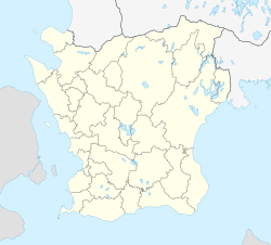
Gunnarstorp (Swedish pronunciation: [ˈɡɵ̂nːaʂˌtɔrp])[2] was a locality situated in Bjuv Municipality, Skåne County, the southernmost province in Sweden.
There were 401 inhabitants in 2010, up from 360 five years earlier.[1] By 2015 it merged with Bjuv and lost its status as a separate locality.
The town grew up around a mine that was sunk in 1910 and worked between 1913 and 1946.
References
[edit]- ^ a b c "Tätorternas landareal, folkmängd och invånare per km2 2005 och 2010" (in Swedish). Statistics Sweden. 14 December 2011. Archived from the original on 27 January 2012. Retrieved 10 January 2012.
- ^ Jöran Sahlgren; Gösta Bergman (1979). Svenska ortnamn med uttalsuppgifter (in Swedish). p. 9.


