Günyüzü
Appearance
(Redirected from Guenyuezue)
Günyüzü | |
|---|---|
District and municipality | |
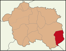
 Map showing Günyüzü District in Eskişehir Province | |
| Coordinates: 39°23′02″N 31°48′36″E / 39.38389°N 31.81000°E | |
| Country | Turkey |
| Province | Eskişehir |
| Government | |
| • Mayor | Hidayet Özmen (BBP) |
| Area | 828 km2 (320 sq mi) |
| Elevation | 871 m (2,858 ft) |
| Population (2022)[1] | 5,155 |
| • Density | 6.2/km2 (16/sq mi) |
| Time zone | UTC+3 (TRT) |
| Postal code | 26630 |
| Area code | 0222 |
| Website | www |
Günyüzü (Turkish: [ˈɟynjyzy]) is a municipality and district of Eskişehir Province, Turkey.[2] Its area is 828 km2,[3] and its population is 5,155 (2022).[1] Its elevation is 871 m (2,858 ft).[4]
Günyüzü became a bucak (subdistrict) in 1932 and gained the status of a district in 1990.
It was in constant interaction with Sivrihisar during the Seljuk and Ottoman periods. It was the scene of important conflicts during the War of Independence and the historical richness of the region became more evident with the excavations.[5]
Places of interest
[edit]Ruins of the Byzantine shrine St Michael at Germia are located in the village of Gümüşkonak, formerly known as Yörme, 8 km south of Günyüzü.
Composition
[edit]There are 22 neighbourhoods in Günyüzü District:[6]
- Atlas
- Ayvalı
- Bedil
- Beyyayla
- Çakmak
- Çardaközü
- Doğray
- Fatih
- Gecek
- Gümüşkonak
- Kavacık
- Kavuncu
- Kayakent
- Kuzören
- Mercan
- Özler
- Sümer
- Tutlu
- Yağrı
- Yazır
- Yenikent
- Yeşilyaka
References
[edit]- ^ a b "Address-based population registration system (ADNKS) results dated 31 December 2022, Favorite Reports" (XLS). TÜİK. Retrieved 12 July 2023.
- ^ Büyükşehir İlçe Belediyesi, Turkey Civil Administration Departments Inventory. Retrieved 12 July 2023.
- ^ "İl ve İlçe Yüz ölçümleri". General Directorate of Mapping. Retrieved 12 July 2023.
- ^ Falling Rain Genomics, Inc. "Geographical information on Günyüzü, Turkey". Retrieved 13 September 2023.
- ^ "Günyüzü nerenin ilçesi, nereye bağlı? Günyüzü hangi şehirde?". Gazete Banka (in Turkish). Retrieved 2023-09-02.
- ^ Mahalle, Turkey Civil Administration Departments Inventory. Retrieved 12 July 2023.
External links
[edit]- District governor's official website (in Turkish)
- District municipality's official website (in Turkish)
- Map of Günyüzü district
- Governorship of Eskişehir, Turkey. "General information on Günyüzü, Eskişehir" (in Turkish). Archived from the original on 2007-11-19.


