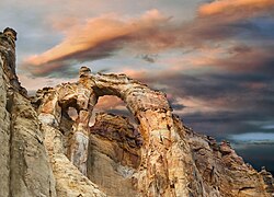
Grosvenor Arch
Appearance
Grosvenor Arch | |
|---|---|
 View of Grosvenor Arch | |
| Coordinates: 37°27′24″N 111°49′54″W / 37.4566526°N 111.8315671°W[1] | |
| Location | Grand Staircase–Escalante National Monument, Utah, United States |
| Dimensions | |
| • Width | 92 ft (28 m) |
| • Height | 150 ft (46 m) |
| Elevation | 6,427 ft (1,959 m) |
Grosvenor Arch is a unique sandstone double arch located within Grand Staircase–Escalante National Monument in southern Kane County, Utah, United States. It is named to honor Gilbert Hovey Grosvenor (1875–1966), a president of the National Geographic Society, publishers of the National Geographic Magazine.[2]
Located in northern Kane County, it is close to and south of Kodachrome Basin State Park and is accessed from the north or south via Cottonwood Canyon Road, a dirt road that traverses Cottonwood Canyon in the western portion of the national monument.[3]
The site is well maintained and has an outhouse restroom and cement benches. There is a concrete sidewalk that goes almost to the base of the arch which is handicap accessible.[4]
References
[edit]- ^ a b "Grosvenor Arch". Geographic Names Information System. United States Geological Survey, United States Department of the Interior.
- ^ Cott, John W. Van (1990). Utah Place Names: A Comprehensive Guide to the Origins of Geographic Names : a Compilation. Salt Lake City: University of Utah Press. p. 169. ISBN 978-0-87480-345-7.
- ^ "Grosvenor Arch". visitsouthernutah.com. Kane County Utah Office of Tourism and Film Commission. Archived from the original on 17 September 2016. Retrieved 31 Mar 2016.
- ^ "Grosvenor Arch". utah.com. Retrieved 31 Mar 2016.
External links
[edit] Media related to Grosvenor Arch at Wikimedia Commons


