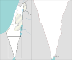
Grofit
Appearance
Grofit
גְּרוֹפִית جروفيت | |
|---|---|
 | |
| Etymology: Shoot | |
| Coordinates: 29°56′28″N 35°3′51″E / 29.94111°N 35.06417°E | |
| Country | Israel |
| District | Southern |
| Council | Hevel Eilot |
| Affiliation | Kibbutz Movement |
| Founded | 1963 |
| Founded by | Nahal |
| Population (2022)[1] | 265 |
| Website | www.grofit.net |
Grofit (Hebrew: גְּרוֹפִית, lit. shoot [of a plant]) is a kibbutz in southern Israel. Located near Eilat in the Arabah region, it falls under the jurisdiction of Hevel Eilot Regional Council. In 2022 it had a population of 265.[1]
History
[edit]The community was founded in 1963 as a Nahal settlement and is named after the Arabic name of the nearby Grofit Creek. In 1966 the kibbutz was settled by adults who had been members of the HaNoar HaOved VeHaLomed youth movement.[2]
Notable people
[edit]- Moshe Ya'alon, Israel's Minister of Defence (2013-2016), IDF Chief of the General Staff (2002-2005)
References
[edit]- ^ a b "Regional Statistics". Israel Central Bureau of Statistics. Retrieved 21 March 2024.
- ^ El'azari, Yuval, ed. (2005). Mapa's Concise Gazetteer of Israel (in Hebrew). Tel Aviv: Mapa Publishing. p. 584. ISBN 965-7184-34-7.
External links
[edit]- Official website Archived 2008-09-15 at the Wayback Machine (in Hebrew)


