Graham Bell Island
Native name: Остров Греэм-Белл | |
|---|---|
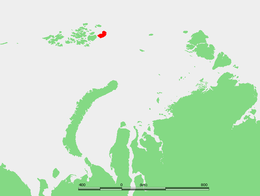
 Location of Graham Bell Island in the Franz Josef Archipelago | |
| Geography | |
| Location | Kara Sea/Barents Sea, Arctic Ocean |
| Coordinates | 80°51′59″N 64°17′21″E / 80.866389°N 64.289167°E |
| Archipelago | Franz Josef Land |
| Area | 1,557 km2 (601 sq mi) |
| Highest elevation | 509 m (1670 ft) |
| Highest point | Kupol Vetrenyy |
| Administration | |
Russia | |
Graham Bell Island (Russian: Остров Греэм-Белл, Ostrov Greem-Bell) is an island in the Franz Josef Archipelago in the Arctic Ocean, and is administratively part of Arkhangelsk Oblast, Russia.
Geography
[edit]Graham Bell Island is one of the largest islands of the group. It lies east of Wilczek Land, separated from it by a narrow sound known as Morgan Sound (Пролив Моргана; Proliv Morgana). It is also the easternmost island of Franz Josef Land. Cape Kohlsaat, the easternmost point of the archipelago at 81°14′N, 65°10′E, lies on Graham Bell Island's eastern shore. Cape Kohlsaat marks the northwesternmost corner of the Kara Sea and is a significant geographical landmark, and it is partly glacierized.
The highest point of Graham Bell Island, 509 m (1,670 ft), is the summit of Kupol Vetrenyy (Купол Ветреный) "Windy Dome", a large ice dome covering the western part of the island.[1]
This island was named after inventor Alexander Graham Bell.[2] Graham Bell Island should not be confused with the smaller Bell Island which is also part of the Franz Josef Archipelago and is named after the shape, not the person.[3][4]
History
[edit]Graham Bell Island was discovered on 2 May 1899 by a sledging party of the Wellman expedition composed of Evelyn Briggs Baldwin, Daniel Johansen, Emil Ellefsen, Olaf Ellefsen, and Paul Bjørvig.[2]
It is home to a Cold War outpost and to the airfield Greem Bell (81°09′N 64°17′E / 81.150°N 64.283°E) on the Northeastern end of the island. It is the largest airfield in the archipelago. It has a runway 2,100 metres (6,900 ft) long. Russian cargo and fighter aircraft have regularly landed here since the 1950s. The runway was usable only in the 8 months of the year with sufficiently frozen ground. Before it was shut down, it was also used for tourist helicopter trips around the Russian arctic as a stopover and refueling base. The base was shut down completely in 1994. It began falling into ruins and was subsequently closed to normal visitors.[5] In May 2012, the Russian Air Force announced it would reopen Graham Bell Airfield as part of a series of reopenings of air bases in the Arctic.[6]
Adjacent islands
[edit]- Graham Bell Island's northern shore is fringed by clusters of very small islets.
- Ostrov Trëkhluchevoy – lies off its western shore at 80°57′06″N 63°04′45″E / 80.9517°N 63.0792°E and is only 2 km in length.
- Ostrov Udachnyy – is part of a cluster of islets located along the NW shores 81°08′30″N 64°08′45″E / 81.1417°N 64.1458°E
See also
[edit]References
[edit]- All locations: [1]
- https://archive.today/20071026183049/http://www.geosite.com.ru/pageid-335-1.html
- Island Directory. Unep.org.
- Graham-Bell Island (Russian).
- Graham-Bell airfield (Russian).
Citations
[edit]- ^ "Kupol Vetrenny". Mapcarta. Retrieved 6 October 2016.
- ^ a b Capelotti, Peter; Forsberg, Magnus (2015). "The place names of Zemlya Frantsa-Iosifa: the Wellman polar expedition, 1898–1899". Polar Record. 51 (261): 624–636. doi:10.1017/S0032247414000801. S2CID 129721098.
- ^ "Холодный, загадочный и прекрасный мир ЭФИ". Archived from the original on 2017-08-03. Retrieved 2016-08-12.
- ^ "Franz-Josef-Land Info - Bell Island, Camp EIRA". Retrieved January 1, 2021.
- ^ "Graham Bell (Greem Bell) Island, Severnaja - Franz-Josef-Land". franz-josef-land.info. Retrieved January 1, 2021.
- ^ Gareth Jennings (12 January 2015). "Russia to build more Arctic airfields". IHS Jane's 360. Archived from the original on January 13, 2015. Retrieved 19 January 2015.
External links
[edit] Media related to Graham Bell Island at Wikimedia Commons

