Gréoux-les-Bains
Appearance
You can help expand this article with text translated from the corresponding article in French. (December 2008) Click [show] for important translation instructions.
|
Gréoux-les-Bains
Grèus (Occitan) | |
|---|---|
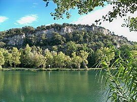
 A view of the river Verdon to the south of the town of Gréoux-les-Bains | |
| Coordinates: 43°45′33″N 5°53′03″E / 43.7592°N 5.8842°E | |
| Country | France |
| Region | Provence-Alpes-Côte d'Azur |
| Department | Alpes-de-Haute-Provence |
| Arrondissement | Forcalquier |
| Canton | Valensole |
| Intercommunality | Durance-Luberon-Verdon Agglomération |
| Government | |
| • Mayor (2020–2026) | Paul Audan[1] |
| Area 1 | 69.46 km2 (26.82 sq mi) |
| Population (2021)[2] | 2,939 |
| • Density | 42/km2 (110/sq mi) |
| Time zone | UTC+01:00 (CET) |
| • Summer (DST) | UTC+02:00 (CEST) |
| INSEE/Postal code | 04094 /04800 |
| Elevation | 268–571 m (879–1,873 ft) (avg. 400 m or 1,300 ft) |
| 1 French Land Register data, which excludes lakes, ponds, glaciers > 1 km2 (0.386 sq mi or 247 acres) and river estuaries. | |
Gréoux-les-Bains (French pronunciation: [ɡʁeu le bɛ̃]; Provençal Occitan: Greù) is a commune in the Alpes-de-Haute-Provence department in the Provence-Alpes-Côte d'Azur region in Southeastern France. Best known for its Château des Templiers, the town is on the right bank of the river Verdon. The commune, on the departmental border with Var, had a population of 2,639 in 2019.
Demographics
[edit]
|
| |||||||||||||||||||||||||||||||||||||||||||||||||||||||||||||||||||||||||||||||||||||||||||||||||||||||||||||||
| Source: EHESS[3] and INSEE (1968-2017)[4] | ||||||||||||||||||||||||||||||||||||||||||||||||||||||||||||||||||||||||||||||||||||||||||||||||||||||||||||||||
See also
[edit]References
[edit]- ^ "Répertoire national des élus: les maires". data.gouv.fr, Plateforme ouverte des données publiques françaises (in French). 2 December 2020.
- ^ "Populations légales 2021" (in French). The National Institute of Statistics and Economic Studies. 28 December 2023.
- ^ Des villages de Cassini aux communes d'aujourd'hui: Commune data sheet Gréoux-les-Bains, EHESS (in French).
- ^ Population en historique depuis 1968, INSEE
Wikimedia Commons has media related to Gréoux-les-Bains.


