Gosné
Appearance
Gosné
| |
|---|---|
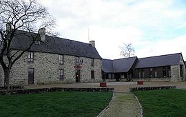
 Town hall | |
| Coordinates: 48°14′49″N 1°27′49″W / 48.2469°N 1.4636°W | |
| Country | France |
| Region | Brittany |
| Department | Ille-et-Vilaine |
| Arrondissement | Rennes |
| Canton | Fougères-1 |
| Intercommunality | Liffré-Cormier Communauté |
| Government | |
| • Mayor (2020–2026) | Jean Dupire[1] |
| Area 1 | 18.14 km2 (7.00 sq mi) |
| Population (2021)[2] | 2,051 |
| • Density | 110/km2 (290/sq mi) |
| Time zone | UTC+01:00 (CET) |
| • Summer (DST) | UTC+02:00 (CEST) |
| INSEE/Postal code | 35121 /35140 |
| Elevation | 53–114 m (174–374 ft) |
| 1 French Land Register data, which excludes lakes, ponds, glaciers > 1 km2 (0.386 sq mi or 247 acres) and river estuaries. | |
Gosné (French pronunciation: [ɡone]; Breton: Goneg; Gallo: Gosnae) is a commune in the Ille-et-Vilaine department in Brittany in northwestern France.
International relations
[edit]It is twinned with Ballyheigue in County Kerry, Ireland.
Population
[edit]Inhabitants of Gosné are called Gosnéens in French.
|
| ||||||||||||||||||||||||||||||||||||||||||||||||||||||||||||||||||||||||||||||||||||||||||||||||||||||||||||||||||
| Source: EHESS[3] and INSEE (1968-2017)[4] | |||||||||||||||||||||||||||||||||||||||||||||||||||||||||||||||||||||||||||||||||||||||||||||||||||||||||||||||||||
Geography
[edit]Gosné is located at 24 km (15 mi) in the North-East of Rennes and at 49 km (30 mi) in the south of the Mont Saint-Michel.
The bordering communes are Saint-Aubin-du-Cormier, Liffré, and Ercé-près-Liffré.
See also
[edit]References
[edit]- ^ "Répertoire national des élus: les maires". data.gouv.fr, Plateforme ouverte des données publiques françaises (in French). 9 August 2021.
- ^ "Populations légales 2021" (in French). The National Institute of Statistics and Economic Studies. 28 December 2023.
- ^ Des villages de Cassini aux communes d'aujourd'hui: Commune data sheet Gosné, EHESS (in French).
- ^ Population en historique depuis 1968, INSEE
External links
[edit]Wikimedia Commons has media related to Gosné.
- Geography of Brittany (in French)
- The page of the commune on infobretagne.com (in French)
- Base Mérimée: Search for heritage in the commune, Ministère français de la Culture. (in French)


