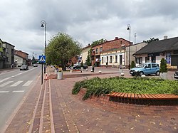
Gorzkowice
Gorzkowice | |
|---|---|
Village | |
 Rynek (Market Square) in Gorzkowice | |
| Coordinates: 51°13′N 19°36′E / 51.217°N 19.600°E | |
| Country | |
| Voivodeship | Łódź |
| County | Piotrków |
| Gmina | Gorzkowice |
| Population | |
• Total | 3,310 |
| Time zone | UTC+1 (CET) |
| • Summer (DST) | UTC+2 (CEST) |
| Vehicle registration | EPI |
| Website | http://www.gorzkowice.pl |
Gorzkowice [ɡɔʂkɔˈvit͡sɛ] is a village in Piotrków County, Łódź Voivodeship, in central Poland. It is the seat of the gmina (administrative district) called Gmina Gorzkowice. It lies approximately 22 kilometres (14 mi) south of Piotrków Trybunalski and 64 km (40 mi) south of the regional capital Łódź.[1] It is located in the Sieradz Land.
History
[edit]
The oldest known mention of the village comes from 1335. The name comes from an Old Polish male name Gorzek. It was a private village of Polish nobility, administratively located in the Piotrków County in the Sieradz Voivodeship in the Greater Poland Province of the Kingdom of Poland.[2]
Following the joint German-Soviet invasion of Poland, which started World War II in September 1939, the village was occupied by Germany until 1945. In September 1944, during the Warsaw Uprising, the Germans deported over 13,000 Varsovians from the Dulag 121 camp in Pruszków, where they were initially imprisoned, to Gorzkowice.[3] Those Poles were mainly old people, ill people and women with children.[3]
In 2008, the village was hit by a tornado which damaged dozens of houses.[4]
Sports
[edit]The local sports club is GUKS Gorzkowice with football, table tennis and chess sections.[5]
References
[edit]- ^ "Central Statistical Office (GUS) - TERYT (National Register of Territorial Land Apportionment Journal)" (in Polish). 2008-06-01.
- ^ Atlas historyczny Polski. Województwo sieradzkie i województwo łęczyckie w drugiej połowie XVI wieku. Część I. Mapy, plany (in Polish). Warszawa: Instytut Historii Polskiej Akademii Nauk. 1998. p. 4.
- ^ a b "Transporty z obozu Dulag 121". Muzeum Dulag 121 (in Polish). Retrieved 6 September 2021.
- ^ Tomasz Mazur. "Gorzkowice. Krajobraz jak po bitwie". Nasze Miasto (in Polish). Retrieved 6 September 2021.
- ^ "GUKS Gorzkowice". Gorzkowice.pl (in Polish). Retrieved 6 September 2021.

