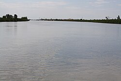
Goro, Emilia–Romagna
Appearance
Goro | |
|---|---|
| Comune di Goro | |
 A view of Pò di Goro in the municipality of Goro | |
| Coordinates: 44°51′N 12°18′E / 44.850°N 12.300°E | |
| Country | Italy |
| Region | Emilia-Romagna |
| Province | Ferrara (FE) |
| Frazioni | Gorino |
| Government | |
| • Mayor | Diego Viviani |
| Area | |
• Total | 33.18 km2 (12.81 sq mi) |
| Elevation | 1 m (3 ft) |
| Population | |
• Total | 3,733 |
| • Density | 110/km2 (290/sq mi) |
| Demonym | Goresi |
| Time zone | UTC+1 (CET) |
| • Summer (DST) | UTC+2 (CEST) |
| Postal code | 44020 |
| Dialing code | 0532 |
| Website | Official website |
Goro (Ferrarese: Gòr, but locally Goro) is a comune (municipality) in the Province of Ferrara in the Italian region Emilia-Romagna, located about 80 kilometres (50 mi) northeast of Bologna and about 50 kilometres (31 mi) east of Ferrara, near the mouth of the Po River.
Goro borders the following municipalities: Ariano nel Polesine, Codigoro, Mesola.
Twin towns
[edit] Pontinia, Italy
Important people
[edit]- Romualdo Rossi (1877-1968) writer, editor and journalist.
- Milva (1939–2021) singer, stage and film actress, and television personality.
- Piergiorgio Farina (1933–2008) jazz violinist, composer and singer.
References
[edit]- ^ "Superficie di Comuni Province e Regioni italiane al 9 ottobre 2011". Italian National Institute of Statistics. Retrieved 16 March 2019.
- ^ Data from Istat
- ^ "Popolazione Residente al 1° Gennaio 2018". Italian National Institute of Statistics. Retrieved 16 March 2019.
External links
[edit]


