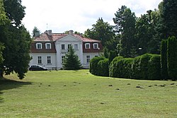
Gierłoż, Kętrzyn County
Gierłoż | |
|---|---|
Village | |
 Palace in Gierłoż | |
| Coordinates: 54°5′0″N 21°30′0″E / 54.08333°N 21.50000°E | |
| Country | |
| Voivodeship | Warmian-Masurian |
| County | Kętrzyn |
| Gmina | Kętrzyn |
| Population | 24 |
| Time zone | UTC+1 (CET) |
| • Summer (DST) | UTC+2 (CEST) |
| Vehicle registration | NKE |
Gierłoż (pronounced g(i)-ER-wuzh [ˈɡʲɛrwɔʂ]) is a village in the administrative district of Gmina Kętrzyn, within Kętrzyn County, Warmian–Masurian Voivodeship, in north-east Poland.[1] It lies approximately 8 kilometres (5 mi) east of Kętrzyn and 74 km (46 mi) north-east of the regional capital Olsztyn. It is located in the historic region of Masuria.
History
[edit]
In 1454 King Casimir IV Jagiellon incorporated the village and region to the Kingdom of Poland upon the request of the Prussian Confederation, and after the subsequent Thirteen Years' War (1454–1466) it was part of Poland as a fief held by the Teutonic Knights.[2] From the 18th century it was part of the Kingdom of Prussia, and from 1871 to 1945 it was part of Germany, administratively located in the province of East Prussia. During World War II, Adolf Hitler's military headquarters from June 21, 1941, to November 20, 1944, were situated here in a bunker, called the Wolf's Lair. After the 1945 defeat of Nazi Germany in the war, the village along with Masuria became again part of Poland.
References
[edit]- ^ "Central Statistical Office (GUS) - TERYT (National Register of Territorial Land Apportionment Journal)" (in Polish). 2008-06-01.
- ^ Górski, Karol (1949). Związek Pruski i poddanie się Prus Polsce: zbiór tekstów źródłowych (in Polish). Poznań: Instytut Zachodni. pp. 54, 96–97, 214–215.

