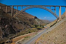
Ghotour Bridge
Appearance

Ghotour Bridge (Persian: پل هوایی خوی) is a railway bridge in Khoy County, West Azerbaijan Province, Iran, over the river Ghotour.[1] It is an arch bridge, and was completed in 1970. It has a length of 442.9 m (1453 ft.) with the largest span being 223.1 m (732 ft.).[2]
Notes
[edit]- ^ "Ghotour Valley Bridge (1970)" en.structurae.de: Nicolas Janberg's Structurae
- ^ "Ghotour Valley Bridge" americanbridge.net[permanent dead link]

