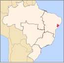
General Maynard
Appearance
General Maynard | |
|---|---|
Municipality | |
| The Municipality of General Maynard | |
 Location of General Maynard in the State of Sergipe | |
| Coordinates: 10°41′15″S 36°57′08″W / 10.68750°S 36.95222°W | |
| Country | |
| Region | Northeast |
| State | |
| Founded | 1963 |
| Government | |
| • Mayor | José Evangelista dos Santos Filho (PSB) |
| Area | |
| • Total | 20.221 km2 (7.807 sq mi) |
| Elevation | 13 m (43 ft) |
| Population (2020 [1]) | |
| • Total | 3,384 |
| • Density | 170/km2 (430/sq mi) |
| Time zone | UTC−3 (BRT) |
| HDI (2000) | 0.671 – medium[2] |
General Maynard is a municipality located in the Brazilian state of Sergipe. Its population was 3,384 (2020) and its area is 20 km².[3]
References
[edit]- ^ IBGE 2020
- ^ "Archived copy". Archived from the original on 2009-10-03. Retrieved 2009-12-17.
{{cite web}}: CS1 maint: archived copy as title (link) - UNDP - ^ IBGE - "Archived copy". Archived from the original on 2008-06-11. Retrieved 2014-08-03.
{{cite web}}: CS1 maint: archived copy as title (link)


