Gelmke
Appearance
| Gelmke | |
|---|---|
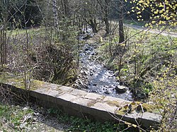
 The Gelmke just upstream of the E 11 trail | |
 | |
| Location | |
| Country | Germany |
| State | Lower Saxony |
| Reference no. | DE: 48214 |
| Physical characteristics | |
| Source | |
| • location | 1.45 km (0.90 mi) ENE of the Dicker Kopf in the Harz |
| • elevation | ca. 510 m above sea level (NN) |
| Mouth | |
• location | near Oker (Goslar) into the Abzucht |
• coordinates | 51°54′36″N 10°28′34″E / 51.910°N 10.476°E |
| Length | ca. 6 km (3.7 mi) |
| Basin size | 4.6 km2 (1.8 sq mi)[1] |
| Basin features | |
| Progression | Abzucht→ Oker→ Aller→ Weser→ North Sea |
| Tributaries | |
| • right | unnamed stream on the Brautstein |
The Gelmke is a small stream, roughly 6 kilometres (3.7 mi) long, and right-hand tributary of the Abzucht in Lower Saxony, Germany. The stream flows through part of the town of Goslar.
Geography
[edit]The Gelmke rises in the Gelmke Valley (Gelmketal) at about 610 m above sea level (NN). Its source lies east-northeast of the hill known as the Dicker Kopf (668 m) and north of the Eichenberg (670 m).[2] It flows initially northwards through a densely wooded valley, where it is crossed by the E 11 European long-distance trail before emerging into open fields and swinging east, just above the old Goslar sewage ponds. It then heads north again to join the Abzucht near Goslar station.[2]
See also
[edit]References
[edit]- ^ NLWK Schriftenreihe Band 4, Gewässergütebericht 2002, Niedesächsischer Landesbetrieb für Wasserwirtschaft und Küstenschutz - Betriebsstelle Süd.
- ^ a b Bad Harzburg, Goslar, Altenau mit Brocken. 5th edition, Publicpress, Geseke. ISBN 978-3-89920-069-0.
