Głęboki Nurt
Appearance
| Głęboki Nurt | |
|---|---|
 Głęboki Nurt in 2009, as seen from the village of Zagórze | |
| Location | Szczecin Lagoon – Dziwna |
| Coordinates | 53°48′55″N 14°36′06″E / 53.81528°N 14.60167°E |
| Type | Strait |
| Basin countries | Poland |
| Settlements | Zagórze |

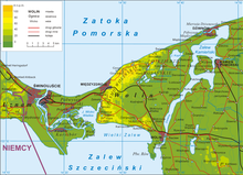
Głęboki Nurt[a][1] is a strait connecting the Szczecin Lagoon and Dziwna channel, located in the West Pomeranian Voivodeship, Poland. It separates the island of Wolin from the Trzebiatów Coast on the mainland.[2]
To the east of the strait, on the mainland, are located Wydrza Góra hill, and the village of Zagórze.[3][4] To the west of the strait, on the island of Wolin, is located Rów peninsula, and to the north-west, Gołogóra hill.[5]
Notes
[edit]References
[edit]- ^ Rozporządzenie Ministra Administracji Publicznej z dnia 11 lutego 1949 r. o przywróceniu i ustaleniu nazw miejscowości. 11 February 1949. In: Monitor Polski z 1949 roku, no. 17, position 225. 1949. (in Polish)
- ^ Ewa Wolnicz-Pawłowska, Jerzy Duma, Janusz Rieger, Halina Czarnecka: Nazewnictwo geograficzne Polski, vol. 1: Hydronimy, part 2: Wody stojące. Warsaw: Główny Urząd Geodezji i Kartografii, 2006, p. 89, ISBN 83-239-9607-5. (in Polish)
- ^ Tadeusz Białecki: Słownik nazw fizjograficznych Pomorza Zachodniego. Szczecin. 2001. p. 498. ISBN 83-7241-201-4. (in Polish)
- ^ "Central Statistical Office (GUS) - TERYT (National Register of Territorial Land Apportionment Journal)" (in Polish). 2008-06-01.
- ^ Prace Komisji Biologicznej, vol. 32, issues 4-7. Poznań: Poznańskie Towarzystwo Przyjaciół Nauk. Komisja Biologiczna. 1968. (in Polish)
