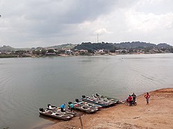
Fresco River
Appearance
| Fresco River | |
|---|---|
 | |
| Native name | Rio Fresco (Portuguese) |
| Location | |
| Country | Brazil |
| Physical characteristics | |
| Mouth | |
• coordinates | 6°38′43″S 52°00′09″W / 6.645151°S 52.002631°W |
| Length | 560 km (350 mi)[1] |
| Basin size | 43,771 km2 (16,900 sq mi) |
| Discharge | |
| • location | São Félix do Xingu, Pará State (near mouth) |
| • average | 865.6 m3/s (30,570 cu ft/s) |
| • minimum | 2.03 m3/s (72 cu ft/s) |
| • maximum | 4,526 m3/s (159,800 cu ft/s) |
| Discharge | |
| • location | Boa Esperança, Pará State (Basin size: 43,030 km2 (16,610 sq mi) |
| • average | 851 m3/s (30,100 cu ft/s) (Period of data: 1970-1996)837 m3/s (29,600 cu ft/s)[2] |
| • minimum | 2 m3/s (71 cu ft/s) |
| • maximum | 4,449 m3/s (157,100 cu ft/s) |
| Basin features | |
| River system | Xingu River |
| Tributaries | |
| • left | Riozinho |
| • right | Trairão |
The Fresco River is a river of Pará state in north-central Brazil. It is a right tributary of Xingu River, which it joins at São Félix do Xingu.
The Fresco River is a blackwater river. Its basin is in the Xingu-Tocantins-Araguaia moist forests ecoregion.[3]
See also
[edit]References
[edit]- ^ Ziesler, R.; Ardizzone, G.D. (1979). "Amazon River System". The Inland waters of Latin America. Food and Agriculture Organization of the United Nations. ISBN 92-5-000780-9. Archived from the original on 21 October 2013.
- ^ Michael, T. Coe; Marcos, Heil Costa; Aurélie, Botta; Charon, Birkett (23 August 2002). "Long-term simulations of discharge and floods in the Amazon Basin". CiteSeerX 10.1.1.549.3854.
- ^ Sears, Robin, Eastern Amazonian - Brazil (NT0180), WWF: World Wildlife Fund, retrieved 22 March 2017

