Fort Gratiot
Fort Gratiot | |
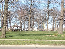
 Pine Grove Park, 2012 - the southern section of Fort Gratiot | |
| Location | Along Thomas Edison Parkway, Port Huron, Michigan[2][3] |
|---|---|
| Coordinates | 42°59′42″N 82°25′41″W / 42.99500°N 82.42806°W |
| Area | 7.5 acres (3.0 ha) |
| Built | 1814 |
| NRHP reference No. | 80004069[1] |
| Added to NRHP | April 14, 1980 |
Fort Gratiot /ˈɡræʃɪt/ was an American stockade fort in Fort Gratiot, Michigan, in Saint Clair County, Michigan. The former location of the fort was listed on the National Register of Historic Places in 1980.[1]
History
[edit]The Army constructed Fort Gratiot in 1814 as an outpost to guard the juncture of the Saint Clair River and Lake Huron. The fort took the name of the engineer supervising its construction, Charles Gratiot. Soldiers occupied Fort Gratiot until 1822 and then abandoned the fort. Lucius Lyon built Fort Gratiot Light north of Fort Gratiot in 1825–1829.
The Army then returned from 1828, and rebuilt the fort to a somewhat smaller size than the original,[4] also building some timber-framed structures on the site, including a hospital and officer's quarters.[5] The site was used intermittently until 1879.[6]
The Army abandoned Fort Gratiot in 1879.[4] It was not entirely shut down until 1895.[7]
Pine Grove Park occupies part of the fort site. The timber-framed hospital and officers quarters were moved multiple times within the fort, finally being placed in the western section, along what is now St. Claire Street. In the 1980s, archaeological work determined the age of the structures, and in 2000–02, the Port Huron Museum acquired both homes and moved them to a lot in Lighthouse Park, where the Fort Gratiot Lighthouse is located. Restoration began in 2012.[5]
Description
[edit]The original fort was constructed entirely of wood. Logs formed the base, with piled earth and upright timbers forming a stockade. The fort was approximately 165 wide feet by 495 feet long. [4][8] It likely had a two-story blockhouse.[6]
Gallery
[edit]-
Entrance to Fort Gratiot, residence square
-
Fort Gratiot from the northwest
References
[edit]- ^ a b "National Register Information System". National Register of Historic Places. National Park Service. July 9, 2010.
- ^ The NRIS lists Fort Gratiot as "Address Restricted," but a historical marker placed along Thomas Edison Parkway, and historical atlases, indicate the location. Geo-coordinates are approximate.
- ^ Oliver F. Waegon (1871), Combination Atlas Map of St. Clair County (PDF), Everts & Stewart, p. 22
- ^ a b c William A. Jenks (January 1920), "Fort Gratiot and Its Builder Gen. Charles Gratiot", Michigan History Magazine: 141–55
- ^ a b "Fort Gratiot Hospital". Port Huron Museum. Retrieved October 25, 2017.
- ^ a b Spencer C. Tucker (2012), The Encyclopedia Of the War Of 1812: A Political, Social, and Military History, ABC-CLIO, p. 257, ISBN 9781851099573
- ^ Walter Romig, Michigan Place Names, p. 204
- ^ Gannett, Henry (1905). The Origin of Certain Place Names in the United States. Govt. Print. Off. pp. 129.
External links
[edit]- Forts in Michigan
- American Civil War forts
- Buildings and structures in St. Clair County, Michigan
- Port Huron, Michigan
- Military history of Michigan
- Military history of the Great Lakes
- Pre-statehood history of Michigan
- 1814 establishments in Michigan Territory
- National Register of Historic Places in St. Clair County, Michigan
- Michigan State Historic Sites in St. Clair County


