Fort D'El-Rei
| Fort D'El-Rei | |
|---|---|
Fortim D'El-Rei | |
| Mindelo, Cape Verde in Cape Verde | |
 | |
| Coordinates | 16°53′26″N 24°59′35″W / 16.89056°N 24.99306°W |
| Site information | |
| Open to the public | Yes |
| Condition | ruins |
| Site history | |
| Built | 1852-1853[1] |
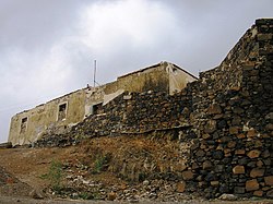
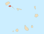
Fort D’El Rei, (Fortim D'El-Rei in Portuguese), also known as Mindelo Fort (Forte do Mindelo in Portuguese) is located in Mindelo, on the Island of São Vicente in Cape Verde.
It was built between 1852 and 1853 and is the oldest construction in the city, having been built to defend the Porto Grande harbour.[1][2] It had 4 18 caliber guns and three 3 caliber guns.[3] It has a wide panoramic view over the city and the bay.
The fortlet is roughly square in shape, with a 30 meters side and a central courtyard in a single storey plan.[1]
In 1924 it housed the ports signal station.[4] It served as a civil jail between 1930 and 1970, purpose which it lost once the Central Jail of Mindelo was built.[1] In 1934, militia descended from the fortlet onto the city on a food riot incited by a local carpenter, Ambrósio.[5] It's been the object of a possible restoration plan to be used for tourism.[1] As of 2012 it was in ruins.[1]
See also
[edit]References
[edit]- ^ a b c d e f Fortim D' El-Rei, Mindelo, Porto Grande, Ilha de São Vicente, Cabo Verde at hpip.org
- ^ Christiano José de Senna Barcellos: Subsidios para a historia de Cabo Verde e Guiné, Volumes 5-7, Typographia da Academia Real das Sciencias, 1911, p.256
- ^ Christiano José de Senna Barcellos: Subsidios para a historia de Cabo Verde e Guiné, Volumes 5-7, Typographia da Academia Real das Sciencias, 1911, p.275
- ^ United States Office of Naval Intelligence: Port Directory of the Principal Foreign Ports, U.S. Government Printing Office, 1928, p.461.
- ^ Aisling Irwin, Colum Wilson: Cape Verde, Bradt Travel Guides, 2011, p. 268.

