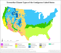
File:US trewartha.svg
Appearance

Size of this PNG preview of this SVG file: 688 × 599 pixels. Other resolutions: 276 × 240 pixels | 551 × 480 pixels | 882 × 768 pixels | 1,176 × 1,024 pixels | 2,351 × 2,048 pixels | 1,488 × 1,296 pixels.
Original file (SVG file, nominally 1,488 × 1,296 pixels, file size: 4.35 MB)
File history
Click on a date/time to view the file as it appeared at that time.
| Date/Time | Thumbnail | Dimensions | User | Comment | |
|---|---|---|---|---|---|
| current | 05:12, 21 April 2020 |  | 1,488 × 1,296 (4.35 MB) | Gringer | Ommitted -> Omitted as per GL:MW |
| 01:08, 10 January 2019 |  | 1,488 × 1,296 (4.35 MB) | Redtitan | Fixed text | |
| 19:20, 9 January 2019 |  | 1,488 × 1,296 (4.39 MB) | Redtitan | Corrected north arrow display | |
| 19:14, 9 January 2019 |  | 1,488 × 1,296 (4.39 MB) | Redtitan | Corrected map of Trewartha using proper boundary for arid climate types, according to Castro et al. Used more appropriate projection and changed color scheme for tropical types. Included new colors for areas that don't match up with Trewartha's scheme, in particular areas classifiable as Cs, except for their annual precipitation exceeding the annual threshold and areas that would be Cf, but have dry summer months (but lack the other necessary characteristics to be classified as Cf) | |
| 18:57, 22 September 2016 |  | 990 × 837 (4.11 MB) | Redtitan | Fixed credits. | |
| 18:33, 22 September 2016 |  | 990 × 837 (4.06 MB) | Redtitan | User created page with UploadWizard |
File usage
The following 7 pages use this file:
Global file usage
The following other wikis use this file:
- Usage on ca.wikipedia.org
- Usage on ms.wikipedia.org
- Usage on pt.wikipedia.org
