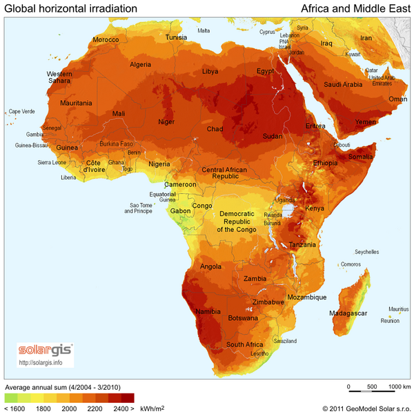
File:SolarGIS-Solar-map-Africa-and-Middle-East-en.png
Appearance

Size of this preview: 600 × 600 pixels. Other resolutions: 240 × 240 pixels | 480 × 480 pixels | 850 × 850 pixels.
Original file (850 × 850 pixels, file size: 561 KB, MIME type: image/png)
File history
Click on a date/time to view the file as it appeared at that time.
| Date/Time | Thumbnail | Dimensions | User | Comment | |
|---|---|---|---|---|---|
| current | 20:32, 30 April 2017 |  | 850 × 850 (561 KB) | Ayane m | 15% file size reduction |
| 12:58, 24 May 2011 |  | 850 × 850 (663 KB) | SolarSoft |
File usage
The following 2 pages use this file:
Global file usage
The following other wikis use this file:
- Usage on af.wikipedia.org
- Usage on ar.wikipedia.org
- Usage on azb.wikipedia.org
- Usage on az.wikipedia.org
- Usage on ca.wikipedia.org
- Usage on cs.wikipedia.org
- Usage on en.wikibooks.org
- Usage on es.wikipedia.org
- Usage on eu.wikipedia.org
- Usage on fa.wikipedia.org
- Usage on ja.wikipedia.org
- Usage on ko.wikipedia.org
- Usage on simple.wikipedia.org
- Usage on uk.wikipedia.org
- Географія Гвінеї
- Географія Ліберії
- Географія Лівії
- Географія Мавританії
- Географія Мадагаскару
- Географія Малі
- Географія Мозамбіку
- Географія Нігеру
- Географія Оману
- Географія Танзанії
- Географія Тунісу
- Географія Уганди
- Географія Намібії
- Географія Замбії
- Географія Катару
- Географія Сьєрра-Леоне
- Географія Демократичної Республіки Конго
- Географія Ботсвани
- Географія Буркіна-Фасо
- Географія Габону
- Географія Гани
- Географія Зімбабве
- Географія Республіки Конго
- Географія Кувейту
- Географія Сейшельських Островів
- Географія Південного Судану
- Географія Еритреї
- Географія Центральноафриканської Республіки
- Географія Анголи
- Географія Бахрейну
- Географія Кенії
- Географія Чаду
- Географія Кот-д'Івуару
- Географія Беніну
View more global usage of this file.
