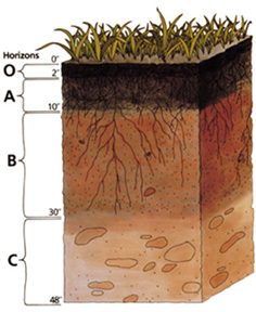
File:Soil profile.jpg
Appearance
Soil_profile.jpg (236 × 288 pixels, file size: 39 KB, MIME type: image/jpeg)
File history
Click on a date/time to view the file as it appeared at that time.
| Date/Time | Thumbnail | Dimensions | User | Comment | |
|---|---|---|---|---|---|
| current | 00:35, 24 November 2004 |  | 236 × 288 (39 KB) | Paleorthid | Soil profile 236x288 38.76 KB {{PD-USGov-USDA}} |
File usage
The following 6 pages use this file:
Global file usage
The following other wikis use this file:
- Usage on af.wikipedia.org
- Usage on ar.wikipedia.org
- Usage on ast.wikipedia.org
- Usage on as.wikipedia.org
- Usage on az.wikipedia.org
- Usage on be-tarask.wikipedia.org
- Usage on be.wikipedia.org
- Usage on bh.wikipedia.org
- Usage on bjn.wikipedia.org
- Usage on bn.wikipedia.org
- Usage on ca.wikipedia.org
- Usage on cs.wikipedia.org
- Usage on cy.wikipedia.org
- Usage on da.wikipedia.org
- Usage on de.wikipedia.org
- Podsol
- Boden (Bodenkunde)
- Solonetz
- Unterboden
- USDA Soil Taxonomy
- Inceptisol
- Entisol
- Andisol
- Gelisol
- Alfisol
- Oxisol
- Histosol
- Spodosol
- Ultisol
- Aridisol
- Vertisol
- Mollisol
- Portal:Geowissenschaften
- Portal:Geowissenschaften/Disziplinen
- Benutzer:BK-Thorsten/Entwurf
- Benutzer:BK-Thorsten
- Acrisol
- Ferralsol
- Nitisol
- Cryosol
View more global usage of this file.


