Jump to content

File:Marree Man comparison.jpg

Page contents not supported in other languages.
This is a file from the Wikimedia Commons
From Wikipedia, the free encyclopedia

Original file (2,308 × 1,977 pixels, file size: 704 KB, MIME type: image/jpeg)

Summary

Description
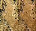
English: Comparison of two satellite images from USGS/NASA's Landsat-5 satellite over the site of the Marree Man geoglyph in outback South Australia. The image on the left, taken on 27 May 1998, shows the desert area untouched. The image on the right, taken on 12 June 1998 over the same area, shows the completed 3.5-kilometre (2.2-mile) long Marree Man.
Date 27 January 2020 (original upload date)
Source Landsat image Gallery (search 27 May 1998 and 12 June 1998)
Author USGS/NASA Landsat project (images combined by Pmallas)

Licensing

Attribution: USGS/NASA Landsat
Public domain This file is in the public domain in the United States because it was solely created by NASA. NASA copyright policy states that "NASA material is not protected by copyright unless noted". (See Template:PD-USGov, NASA copyright policy page or JPL Image Use Policy.)
Warnings:

Captions

Comparison of two satellite images of the site of the Marree Man geoglyph in Australia, May and June 1998

Items portrayed in this file

depicts

27 January 2020

image/jpeg

File history

Click on a date/time to view the file as it appeared at that time.

Date/TimeThumbnailDimensionsUserComment
current06:03, 19 August 2024Thumbnail for version as of 06:03, 19 August 20242,308 × 1,977 (704 KB)SCHolar44Lightened photograph to more readily show geoglyph
13:21, 28 January 2020Thumbnail for version as of 13:21, 28 January 20202,308 × 1,977 (585 KB)PmallasUser created page with UploadWizard

The following page uses this file:

Global file usage

The following other wikis use this file:

Metadata