Jump to content

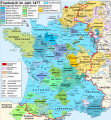
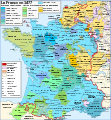
File:Map France 1477-de.svg

Page contents not supported in other languages.
This is a file from the Wikimedia Commons
From Wikipedia, the free encyclopedia

Original file (SVG file, nominally 900 × 970 pixels, file size: 2.74 MB)

Summary

Description
Deutsch: Karte Frankreichs im Jahr 1477.
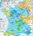
Français : Carte de la France en 1477.
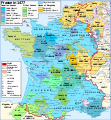
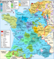
English: Map of France in 1477.
Date (UTC)
Source
Author
Permission
(Reusing this file)
I, the copyright holder of this work, hereby publish it under the following licenses:
w:en:Creative Commons
attribution share alike
This file is licensed under the Creative Commons Attribution-Share Alike 2.5 Generic license.
You are free:
  • to share – to copy, distribute and transmit the work
  • to remix – to adapt the work
Under the following conditions:
  • attribution – You must give appropriate credit, provide a link to the license, and indicate if changes were made. You may do so in any reasonable manner, but not in any way that suggests the licensor endorses you or your use.
  • share alike – If you remix, transform, or build upon the material, you must distribute your contributions under the same or compatible license as the original.
w:en:Creative Commons
attribution share alike
This file is licensed under the Creative Commons Attribution-Share Alike 3.0 Unported license.
You are free:
  • to share – to copy, distribute and transmit the work
  • to remix – to adapt the work
Under the following conditions:
  • attribution – You must give appropriate credit, provide a link to the license, and indicate if changes were made. You may do so in any reasonable manner, but not in any way that suggests the licensor endorses you or your use.
  • share alike – If you remix, transform, or build upon the material, you must distribute your contributions under the same or compatible license as the original.
This licensing tag was added to this file as part of the GFDL licensing update.
GNU head Permission is granted to copy, distribute and/or modify this document under the terms of the GNU Free Documentation License, Version 1.2 or any later version published by the Free Software Foundation; with no Invariant Sections, no Front-Cover Texts, and no Back-Cover Texts. A copy of the license is included in the section entitled GNU Free Documentation License.
You may select the license of your choice.
Other versions

[edit]


This is a retouched picture, which means that it has been digitally altered from its original version. Modifications: traduction allemand / deutsche Übersetzung / German translation. The original can be viewed here: Map France 1477-fr.svg. Modifications made by Furfur.

Original upload log

This image is a derivative work of the following images:

  • File:Map_France_1477-fr.svg licensed with Cc-by-sa-2.5, Cc-by-sa-3.0-migrated, GFDL
    • 2007-04-20T11:10:17Z Bibi Saint-Pol 900x970 (1280806 Bytes) {{Created with Inkscape}} == Description == {{Information |Description= {{en|Map of the France in 1477.}} {{fr|Carte de la France en 1477.}} |Source= {{fr| *[[:Image:France XVe siècle.jpg|France in the late 15th century]], t

Uploaded with derivativeFX

Legende

 
Krondomäne (Domaine royal):

Rote Linie: Grenze des Königreichs Frankreich


Kapetingische Häuser (Valois, Bourbon):

 
Valois-Alençon:

— Herzogtum Alençon (1220)

— Grafschaft Perche (1227)

 
Valois-Anjou:

— Herzogtum Anjou (1204)

— Grafschaft Provence (1498)

— Herzogtum Bar (1766)

Karl V. von Anjou:

— Grafschaft Maine (1204)

— Grafschaft Guise (1688)

— Grafschaft Gien (1199)

— Vizegrafschaft Châtellerault (1482)

 
Valois-Orléans (Ludwig von Orléans, der spätere König Ludwig XII.):

— Herzogtum Orléans (987)

— Herzogtum Valois (1214)

 
Orléans-Dunois (Franz I. von Orléans, Sohn von Jean de Dunois:

— Grafschaft Dunois (1707)

— Grafschaft Longueville (XIII. Jahrhundert)

— Herrschaft Parthenay (1419)

 
Valois-Angoulême (Karl von Orléans (1459-1496)):

— Grafschaft Angoulême (1308)

 
Bourbon (Johann II. von Bourbon):

— Herzogtum Bourbon (1531)

— Herzogtum Auvergne (seit 1200)

— Grafschaft Forez (1531)

— Grafschaft Clermont (1218)

Peter II. von Bourbon:

— Herrschaft Beaujeu (1531)

Andere Häuser:


Haus Burgund:

 
Haus Burgund (Karl der Kühne):

— Herzogtum Burgund (1016)

— Grafschaft Charolais (1751)

— Sundgau (1648)

— Picardie (XII.-XIII. Jahrhundert)

— Grafschaft Artois (1185)

— Grafschaft Hennegau (1659, 1678)

— Grafschaft Flandern (1678)

— Herzogtum Brabant (-)

— Herzogtum Geldern (-)

 
Haus Bourgogne-Nevers (Johann von Burgund (1415-1491)):

— Grafschaft Nevers (?)

— Grafschaft Rethel (?)

— Grafschaft Eu (?)


Haus Foix (Franz Phébus):

— Grafschaft Foix (1589)

— Grafschaft Bigorre (1322)

— Vizegrafschaft Béarn (1589)

— Königreich Navarra (1589)

— Fürstentum Andorre (-)

Johann von Foix-Étampes, Bruder von Franz Phébus:

— Vizegrafschaft Narbonne (1507)

 
Haus Armagnac (Karl I. von Armagnac):

— Grafschaft Armagnac (1589)

— Grafschaft Rodez (1589)

Jacques d'Armagnac-Nemours, Graf von Pardiac:

— Grafschaft Marche (1531)

— Herzogtum Nemours (1274)

 
Haus Albret (Alain d'Albret):

— Herrschaft Albret (1589)

— Vizegrafschaft Limoges (1589)

— Grafschaft Périgord (1589)


Verschiedene Häuser:

Haus Bretagne (Franz II.):

— Herzogtum Bretagne (1532)

— Grafschaft Vertus (1284)

Haus Montpensier (Ludwig I. von Montpensier, Grafschaft Montpensier und Dauphin d'Auvergne):

— Grafschaft Sancerre (1434)

Haus Chalon (Johann IV. von Chalon-Arlay):

— Fürstentum Orange (1673)

Haus Husson-Tonnerre (Karl von Husson):

— Grafschaft Tonnerre (?)

Haus Lothringen (Rainer II. von Lothringen):

— Grafschaft Aumale (1194)

?

— Vizegrafschaft Soule (1510 [1])


Lehen des Königreichs:

— Grafschaft Roussillon (1659)

— Herzogtum Savoyen (Bresse, Bugey, Gex: 1601, Savoyen: 1860)

— Herzogtum Lothringen (1766)

— Grafschaft Montbéliard (Mömpelgard) (1793)

— Grafschaft Blâmont (1766)

— Fürstentum Salm (1793)

 
Kirchlicher Besitz:

— Grafschaft Venaissin, Avignon (päpstlicher Besitz) (1791)

— Bistümer Metz, Verdun und Toul (1552-1648)

— Cambrai (1678)

 
Freie Reichsstädte
 
Englische Besitzungen


(1589): Jahr der Eingliederung in die Krondomäne bzw. in den französischen Staat

Captions

Add a one-line explanation of what this file represents

Items portrayed in this file

depicts

22 September 2010

File history

Click on a date/time to view the file as it appeared at that time.

Date/TimeThumbnailDimensionsUserComment
current08:30, 23 September 2010Thumbnail for version as of 08:30, 23 September 2010900 × 970 (2.74 MB)FurfurSchriften in Konturen umgewandelt
08:19, 23 September 2010Thumbnail for version as of 08:19, 23 September 2010900 × 970 (600 KB)Furfurkleine Korrektur
19:51, 22 September 2010Thumbnail for version as of 19:51, 22 September 2010900 × 970 (2.66 MB)FurfurFehlerkorrektur
19:45, 22 September 2010Thumbnail for version as of 19:45, 22 September 2010900 × 970 (2.66 MB)Furfurkosmetische Änderungen
19:07, 22 September 2010Thumbnail for version as of 19:07, 22 September 2010900 × 970 (2.66 MB)Furfur {{Information |Description={{de|Karte Frankreichs im Jahr 1477.}} {{fr|Carte de la France en 1477.}} {{en|Map of France in 1477.}} |Source=*File:Map_France_1477-fr.svg |Date=2010-09-22 19:03 (UTC) |Author=*File:Map_France_1477-fr.svg: [[User:

The following page uses this file:

Global file usage