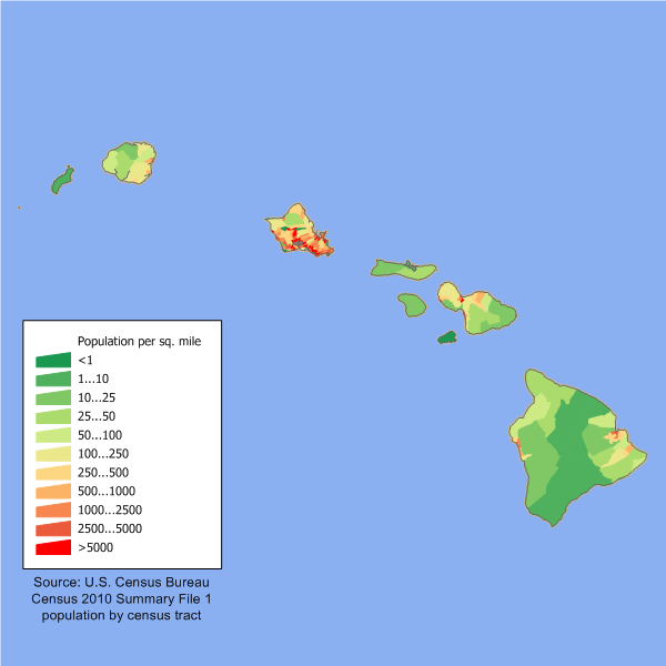
File:Hawaii population map.png
Appearance
Hawaii_population_map.png (600 × 600 pixels, file size: 52 KB, MIME type: image/png)
File history
Click on a date/time to view the file as it appeared at that time.
| Date/Time | Thumbnail | Dimensions | User | Comment | |
|---|---|---|---|---|---|
| current | 14:03, 11 December 2011 |  | 600 × 600 (52 KB) | JimIrwin | 2010 census update |
| 01:04, 29 May 2008 |  | 660 × 480 (13 KB) | Viriditas | {{Information |Description={{en|en:Category:U.S. State Population Maps en:Category:Hawaii maps == Summary == Hawaii state population density map based on Census 2000 data. See the data lineage fo | |
| 19:39, 12 May 2008 |  | 660 × 480 (13 KB) | File Upload Bot (Magnus Manske) | {{BotMoveToCommons|en.wikipedia}} {{Information |Description={{en|en:Category:U.S. State Population Maps en:Category:Hawaii maps Hawaii state population density map based on Census 2000 data. See the [[:en:User:JimIrwin/Lineage_of_population_ |
File usage
The following 2 pages use this file:
Global file usage
The following other wikis use this file:
- Usage on cy.wikipedia.org
- Usage on de.wikipedia.org
- Usage on el.wikipedia.org
- Usage on es.wikipedia.org
- Usage on fr.wikipedia.org
- Usage on fy.wikipedia.org
- Usage on he.wikipedia.org
- Usage on ja.wikipedia.org
- Usage on kn.wikipedia.org
- Usage on ml.wikipedia.org
- Usage on no.wikipedia.org
- Usage on pl.wikipedia.org
- Usage on ro.wikipedia.org
- Usage on ru.wikibooks.org
- Usage on ru.wikivoyage.org


