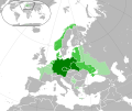
File:German Reich 1942 (Extended).svg
Appearance

Size of this PNG preview of this SVG file: 512 × 431 pixels. Other resolutions: 285 × 240 pixels | 570 × 480 pixels | 912 × 768 pixels | 1,217 × 1,024 pixels | 2,433 × 2,048 pixels.
Original file (SVG file, nominally 512 × 431 pixels, file size: 7.11 MB)
File history
Click on a date/time to view the file as it appeared at that time.
| Date/Time | Thumbnail | Dimensions | User | Comment | |
|---|---|---|---|---|---|
| current | 13:31, 28 October 2023 |  | 512 × 431 (7.11 MB) | Qbox673 | dashed lines for sub-national boundaries |
| 19:11, 7 April 2023 |  | 512 × 431 (2.97 MB) | Qbox673 | Reverted to version as of 18:56, 7 April 2023 (UTC) | |
| 19:09, 7 April 2023 |  | 512 × 431 (2.92 MB) | Qbox673 | reupload test | |
| 18:56, 7 April 2023 |  | 512 × 431 (2.97 MB) | Qbox673 | reupload, bugged thumbnail | |
| 18:42, 7 April 2023 |  | 512 × 431 (5.88 MB) | Qbox673 | Svalbard and Jan Mayen | |
| 17:26, 7 April 2023 |  | 512 × 431 (5.88 MB) | Qbox673 | greece edit | |
| 03:05, 17 March 2023 |  | 512 × 431 (5.87 MB) | Qbox673 | Reupload test | |
| 22:29, 9 March 2023 |  | 512 × 431 (10.9 MB) | Qbox673 | Reupload, bugged thumbnail | |
| 19:14, 6 March 2023 |  | 512 × 431 (10.89 MB) | Qbox673 | Separated northern & southern Algerian territories | |
| 02:53, 24 February 2023 |  | 512 × 431 (11.16 MB) | Qbox673 | graticule & map in corner |
File usage
The following 4 pages use this file:
Global file usage
The following other wikis use this file:
- Usage on fa.wikipedia.org
- Usage on sr.wikipedia.org
- Usage on vi.wikipedia.org
- Usage on zh.wikipedia.org

