
File:Dhauliganga and Rishiganga Valleys.jpg

Size of this preview: 411 × 600 pixels. Other resolutions: 164 × 240 pixels | 329 × 480 pixels | 526 × 768 pixels | 702 × 1,024 pixels | 1,925 × 2,809 pixels.
Original file (1,925 × 2,809 pixels, file size: 2.76 MB, MIME type: image/jpeg)
| This is a file from the Wikimedia Commons. Information from its description page there is shown below. Commons is a freely licensed media file repository. You can help. |
Summary
| Description |
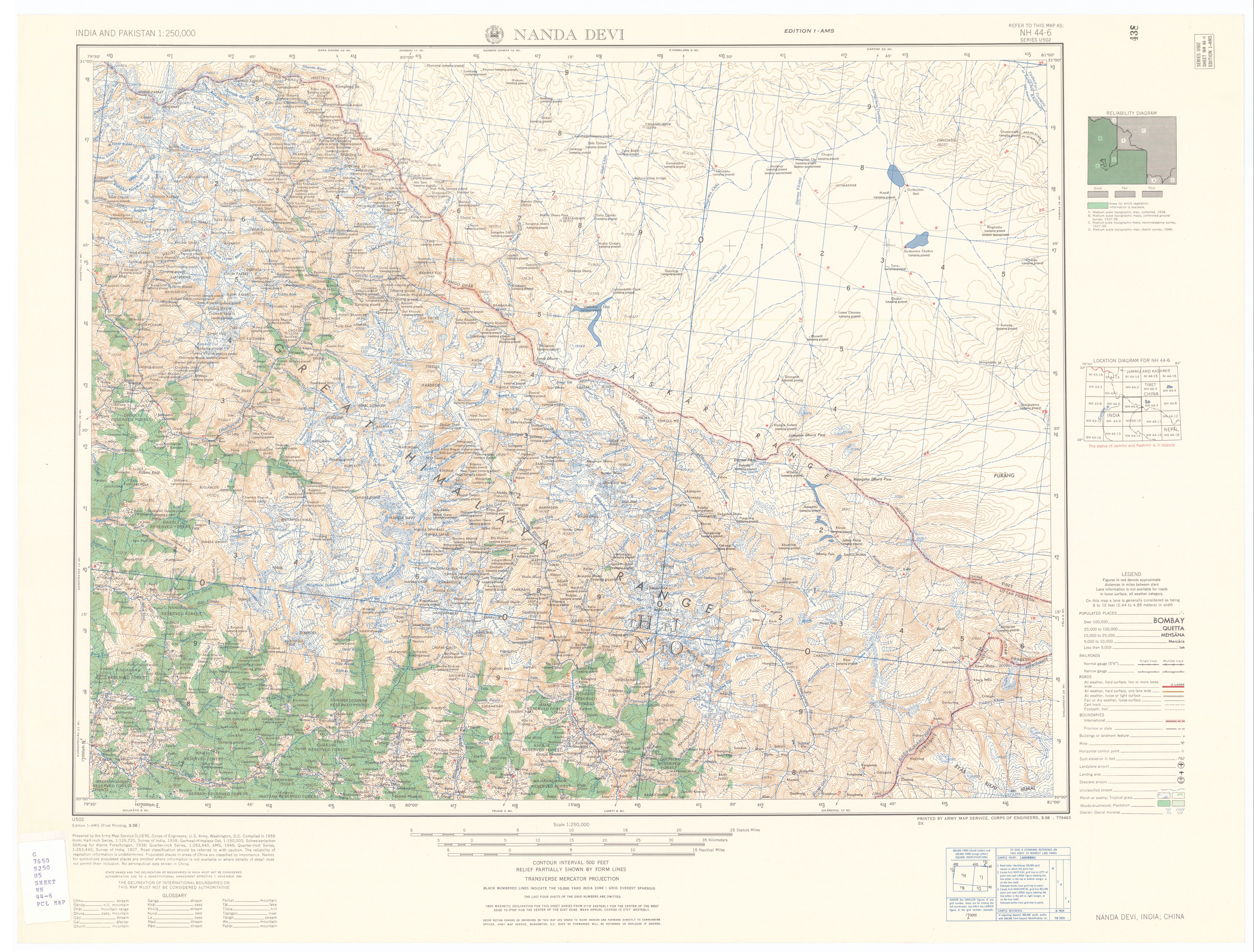
English: The Dhauliganga and Rishiganga river valleys in the Garhwal Himalayas of Uttarakhand state, India |
||||||||||||||||||||||||
| Date | |||||||||||||||||||||||||
| Source | From the Map NH 44-6 series U502 in India and Pakistan 1:250,000 Series U502, U.S. Army Map Service, 1955- at the University of Texas at Austin, Perry-Castañeda Library Map Collection. | ||||||||||||||||||||||||
| Creator |
Prepared by the US Army Map Service (LUEN), Corps of Engineers, U. S. Army, Washington, D. C. Compiled in 1955 (from: Half-inch Series, 1:125,720, Survey of India, 1938; Garhwal-Himalaya-Ost, 1:150,000, Schweizerischen Stiftung fur Alpine Forschungen, 1938; Quarter-inch Series, 1:253,440, AMS, 1946; Quarter-inch Series, 1:253,440, Survey of India, 1927). Cropped and map margins edited by Fowler&fowler (talk) 00:36, 10 February 2021 (UTC) |
||||||||||||||||||||||||
| Georeferencing | If inappropriate please set warp_status = skip to hide. | ||||||||||||||||||||||||
| Other versions |
|

.jpg)

| Camera location | | View this and other nearby images on: OpenStreetMap |
|---|
Licensing
This work is in the public domain in the United States because it is a work prepared by an officer or employee of the United States Government as part of that person’s official duties under the terms of Title 17, Chapter 1, Section 105 of the US Code.
Note: This only applies to original works of the Federal Government and not to the work of any individual U.S. state, territory, commonwealth, county, municipality, or any other subdivision. This template also does not apply to postage stamp designs published by the United States Postal Service since 1978. (See § 313.6(C)(1) of Compendium of U.S. Copyright Office Practices). It also does not apply to certain US coins; see The US Mint Terms of Use.
|
 | |
| This file has been identified as being free of known restrictions under copyright law, including all related and neighboring rights. | ||
File history
Click on a date/time to view the file as it appeared at that time.
| Date/Time | Thumbnail | Dimensions | User | Comment | |
|---|---|---|---|---|---|
| current | 00:36, 10 February 2021 | | 1,925 × 2,809 (2.76 MB) | Fowler&fowler | Uploaded a work by Prepared by the US Army Map Service (LUEN), Corps of Engineers, U. S. Army, Washington, D. C. Compiled in 1955 (from: Half-inch Series, 1:125,720, Survey of India, 1938; Garhwal-Himalaya-Ost, 1:150,000, Schweizerischen Stiftung fur Alpine Forschungen, 1938; Quarter-inch Series, 1:253,440, AMS, 1946; Quarter-inch Series, 1:253,440, Survey of India, 1927). Cropped and map margins edited by ~~~~ from From the [http://legacy.lib.utexas.edu/maps/ams/india/nh-44-06.jpg Map NH 44... |
File usage
The following 3 pages use this file:
Global file usage
The following other wikis use this file:
- Usage on fa.wikipedia.org
- Usage on hi.wikipedia.org
- Usage on kn.wikipedia.org
- Usage on th.wikipedia.org
- Usage on ur.wikipedia.org