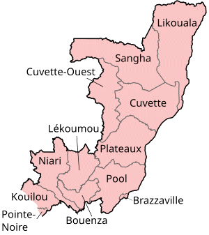
File:Congo regions named.png
Appearance
Congo_regions_named.png (300 × 337 pixels, file size: 14 KB, MIME type: image/png)
File history
Click on a date/time to view the file as it appeared at that time.
| Date/Time | Thumbnail | Dimensions | User | Comment | |
|---|---|---|---|---|---|
| current | 17:29, 1 October 2023 |  | 300 × 337 (14 KB) | Yunan973 | fix all boundaries according to last offical maps (2023) |
| 16:53, 28 December 2004 |  | 300 × 370 (13 KB) | Golbez | Map of the regions of the Republic of the Congo. Made by User:Golbez. {{cc-by-sa-2.0}} |
File usage
The following 100 pages use this file:
- Abala District
- Allembé District
- Bambama District
- Banda District (Republic of the Congo)
- Boko-Songho District
- Boko District
- Bokoma District
- Bouanéla District
- Boundji District
- Bétou District
- Departments of the Republic of the Congo
- Districts of the Republic of the Congo
- Divénié District
- Djambala District
- Dongou District
- Enyellé District
- Epena District
- Etoumbi District
- Ewo District
- Gamboma District
- Goma Tsé-Tsé District
- Hinda District
- Ignié District
- Ile Mbamou
- Impfondo District
- Kabo District
- Kakamoeka District
- Kayes District
- Kelle District
- Kibangou District
- Kimba District
- Kimongo District
- Kindamba District
- Kingoué District
- Kinkala District
- Komono District
- Liranga District
- Loango District
- Londéla–Kayes District
- Loudima District
- Louingui District
- Loukela District
- Loukoléla District
- Loumo District
- Louvakou District
- Lékana District
- Mabombo District
- Madingo-Kayes District
- Madingou District
- Makabana District
- Makotimpoko District
- Makoua District
- Mayama District
- Mayoko District
- Mayéyé District
- Mbama District (Republic of the Congo)
- Mbanza–Ndounga District
- Mbinda District
- Mbomo District
- Mbon District
- Mfouati District
- Mindouli District
- Mokéko District
- Mossaka District
- Moungoundou-nord District
- Moungoundou-sud District
- Moutamba District
- Mouyondzi District
- Mpouya District
- Mvouti District
- N'gbala District
- Ngabé District
- Ngo District
- Ngoko District
- Ntokou District
- Nyanga District (Republic of the Congo)
- Nzambi District
- Okoyo District
- Ollombo District
- Ongogni District
- Ouésso District
- Oyo District
- Pikounda District
- Pointe-Noire
- Republic of the Congo
- Sembé District
- Sibiti District
- Souanké District
- Tchiamba-Nzassi
- Tchikapika District
- Tsiaki District
- Vindza District
- Yamba District (Republic of the Congo)
- Yaya District (Republic of the Congo)
- Zanaga District
- User:Jonny-mt/Gallery of current first-level administrative country subdivisions maps
- User talk:Markussep/Archive 4
- Template:Departments of the Republic of the Congo Image Map
- Template:Districts of the Republic of the Congo
- Portal:Republic of the Congo
Global file usage
The following other wikis use this file:
- Usage on ast.wikipedia.org
- Usage on avk.wikipedia.org
- Usage on be-tarask.wikipedia.org
- Usage on bg.wikipedia.org
- Usage on bn.wikipedia.org
- Usage on br.wikipedia.org
- Usage on ca.wikipedia.org
- Usage on de.wikipedia.org
- Usage on el.wikipedia.org
- Usage on es.wikipedia.org
- Usage on eu.wikipedia.org
- Usage on fa.wikipedia.org
- Usage on fi.wikipedia.org
- Usage on frr.wikipedia.org
- Usage on fr.wikipedia.org
- Usage on gl.wikipedia.org
- Usage on he.wikipedia.org
- Usage on hr.wikipedia.org
- Usage on hu.wikipedia.org
- Usage on id.wikipedia.org
- Usage on is.wikipedia.org
- Usage on it.wikipedia.org
- Usage on ja.wikipedia.org
- Usage on ka.wikipedia.org
- Usage on kg.wikipedia.org
- Usage on kk.wikipedia.org
- Usage on ko.wikipedia.org
- Usage on li.wikipedia.org
- Usage on ln.wikipedia.org
- Usage on lt.wikipedia.org
- Usage on mt.wikipedia.org
- Usage on mzn.wikipedia.org
- Usage on nl.wikipedia.org
- Usage on nn.wikipedia.org
- Usage on no.wikipedia.org
View more global usage of this file.


