
File:Bracondale Riding Boundary Map 1937–1967.tiff
Size of this PNG preview of this TIF file: 463 × 599 pixels. Other resolutions: 185 × 240 pixels | 371 × 480 pixels | 593 × 768 pixels | 791 × 1,024 pixels | 2,549 × 3,299 pixels.
Original file (2,549 × 3,299 pixels, file size: 645 KB, MIME type: image/tiff)
| This is a file from the Wikimedia Commons. Information from its description page there is shown below. Commons is a freely licensed media file repository. You can help. |
Summary
| Description |
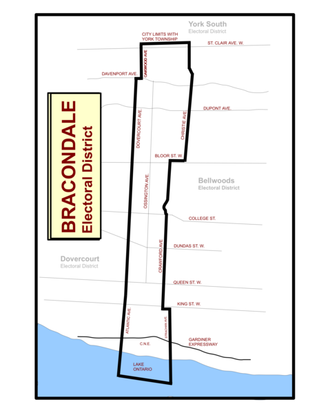
English: This is a representation of what the riding boundary map for the Ontario provincial riding of Bracondale would look like between 1937 to 1967. The 1926–1937 boundaries are similar. |
| Date | |
| Source | Own work |
| Author | Abebenjoe |
Licensing
I, the copyright holder of this work, hereby publish it under the following license:
This file is licensed under the Creative Commons Attribution-Share Alike 3.0 Unported license.
- You are free:
- to share – to copy, distribute and transmit the work
- to remix – to adapt the work
- Under the following conditions:
- attribution – You must give appropriate credit, provide a link to the license, and indicate if changes were made. You may do so in any reasonable manner, but not in any way that suggests the licensor endorses you or your use.
- share alike – If you remix, transform, or build upon the material, you must distribute your contributions under the same or compatible license as the original.
File history
Click on a date/time to view the file as it appeared at that time.
| Date/Time | Thumbnail | Dimensions | User | Comment | |
|---|---|---|---|---|---|
| current | 18:12, 13 November 2011 |  | 2,549 × 3,299 (645 KB) | Abebenjoe | Added Oakwood Ave. as the northwestern boundary. Added colour to Lake Ontario, and slightly adjusted the lake's boundaries. |
| 02:26, 12 November 2011 |  | 2,549 × 3,299 (585 KB) | Abebenjoe |
File usage
The following pages on the English Wikipedia use this file (pages on other projects are not listed):