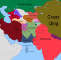
File:Afghanistan 1860.png
Appearance

Size of this preview: 607 × 599 pixels. Other resolutions: 243 × 240 pixels | 486 × 480 pixels | 778 × 768 pixels | 1,037 × 1,024 pixels | 1,673 × 1,652 pixels.
Original file (1,673 × 1,652 pixels, file size: 206 KB, MIME type: image/png)
File history
Click on a date/time to view the file as it appeared at that time.
| Date/Time | Thumbnail | Dimensions | User | Comment | |
|---|---|---|---|---|---|
| current | 01:08, 2 March 2022 |  | 1,673 × 1,652 (206 KB) | Noorullah21 | added credits and a possible info of contact if needed |
| 02:10, 20 January 2022 |  | 1,673 × 1,652 (172 KB) | Noorullah21 | fixed kokand-qing-russian border..........again | |
| 04:05, 19 January 2022 |  | 1,673 × 1,652 (169 KB) | Noorullah21 | fixed russian-qing border | |
| 02:17, 17 January 2022 |  | 1,673 × 1,652 (170 KB) | Noorullah21 | THE FINAL FINISH TO CENTRAL ASIA! Bukhara, kokand hissar added, russian borders with qing fixed, khiva fixed, turkomen revolt fixed. | |
| 06:36, 7 January 2022 |  | 1,673 × 1,652 (162 KB) | Noorullah21 | Added russia, khiva, turkomen revolt/civil war for old khiva, and some other small nations and changes to maimana border, etc. | |
| 20:00, 13 December 2021 |  | 1,673 × 1,652 (158 KB) | Weaveravel | further minor crop to centerize with taking present borders into consideration | |
| 04:02, 13 December 2021 |  | 1,717 × 1,652 (161 KB) | Noorullah21 | fixes to shighnan border, roshan was a province of them | |
| 01:21, 11 December 2021 |  | 1,717 × 1,652 (156 KB) | Weaveravel | cropped to centerize Afg | |
| 21:44, 4 December 2021 |  | 1,865 × 1,725 (153 KB) | Noorullah21 | Big changes to map, made herat, kalat, british borders more accurate with afghanistan. and fixes to sindh border with kalat | |
| 03:08, 30 November 2021 |  | 1,865 × 1,725 (148 KB) | Noorullah21 | Fixed darvaz and shighnan region to be more accurate, specifically fixed afghan, shignan, darvaz, and roshan borders. |
File usage
The following 9 pages use this file:
Global file usage
The following other wikis use this file:
- Usage on bn.wikipedia.org
- Usage on fa.wikipedia.org
- Usage on id.wikipedia.org
- Usage on pnb.wikipedia.org
- Usage on ps.wikipedia.org
- Usage on ru.wikipedia.org
- Usage on uk.wikipedia.org
- Usage on ur.wikipedia.org
