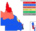
File:2017 Queensland state election map.svg
Appearance

Size of this PNG preview of this SVG file: 575 × 500 pixels. Other resolutions: 276 × 240 pixels | 552 × 480 pixels | 883 × 768 pixels | 1,178 × 1,024 pixels | 2,355 × 2,048 pixels.
Original file (SVG file, nominally 575 × 500 pixels, file size: 120 KB)
File history
Click on a date/time to view the file as it appeared at that time.
| Date/Time | Thumbnail | Dimensions | User | Comment | |
|---|---|---|---|---|---|
| current | 11:49, 19 October 2018 |  | 575 × 500 (120 KB) | JoKalliauer | Wikipedia:SVG_help#[librsvgbug] _Fonts_are_affected_when_size_of_images_is_decreased real text again, phab:T36947 |
| 18:30, 18 October 2018 |  | 575 × 500 (355 KB) | SD604 | possibly fixed text? | |
| 18:28, 18 October 2018 |  | 575 × 500 (261 KB) | SD604 | possibly fixed text? | |
| 20:52, 14 October 2018 |  | 575 × 500 (260 KB) | SD604 | {{Information |description ={{en|1=Map of the 2017 Queensland state election results by electoral district. }} |date =2018-10-14 |source ={{own}} |author =[https://en.wikipedia.org/wiki/User%3AJDuggan101 JDuggan101] |permission ={{PD-user-en|JDuggan101}} }} Category:Queensland State elections |
File usage
The following page uses this file:
