Feuerspitze
Appearance
| Feuerspitze | |
|---|---|
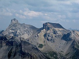
 Wetterspitze (left) and Feuerspitze (right), seen from the southwest | |
| Highest point | |
| Elevation | 2,852 m (9,357 ft) |
| Coordinates | 47°12′0″N 10°22′0″E / 47.20000°N 10.36667°E |
| Geography | |
| Location | Tyrol, Austria |
| Parent range | Lechtal Alps |
Feuerspitze ("Fire-Peak") is a mountain in the Lechtal Alps of Tyrol. The elevation at its peak is 2,852 metres (9,357 ft).[1] Feuerspitze is located 7 kilometres (4.3 mi) southeast of Holzgau.
From the Ansbacher Hütte, it takes three hours to climb to the summit of Feuerspitze.[2]
References
[edit]- ^ Reichart, Thomas (2 March 2024). "Brennen für die Feuerspitze". BR (in German). Retrieved 19 August 2024.
- ^ "Ansbacher Hütte". Berg Welten. Retrieved 19 August 2024.

