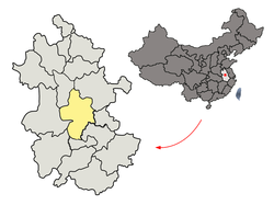
Feixi County
Appearance
Feixi
肥西县 | |
|---|---|
 | |
 Feixi in Hefei | |
 Hefei in Anhui | |
| Country | China |
| Province | Anhui |
| Prefecture-level city | Hefei |
| County seat | Shangpai |
| Government | |
| Area | |
| • Total | 2,053.19 km2 (792.74 sq mi) |
| Population (2020) | |
| • Total | 967,508 |
| • Density | 470/km2 (1,200/sq mi) |
| Time zone | UTC+8 (China Standard) |
| Postal code | 231200 |
| Website | www |
Feixi County (simplified Chinese: 肥西县; traditional Chinese: 肥西縣; pinyin: Féixī Xiàn) is a county of Anhui Province, East China, it is under the administration of the prefecture-level city of Hefei, the capital of Anhui. The county has an area of 2,053.19 km2 (792.74 sq mi) and a population of 858,895 inhabitants.[1]
Administrative divisions
[edit]Feixi County is divided to 8 towns and 2 townships.[2][3][4]
- Towns
Shangpai (上派镇), Sanhe (三河镇), Guanting (官亭镇), Shannan (山南镇), Huagang (花岗镇), Zipeng (紫蓬镇), Taohua (桃花镇), Fengle (丰乐镇)Gaodian (高店镇)
- Townships
Mingchuan Township (铭传乡), Shishugang Township (柿树岗乡), Yandian Township (严店乡)
- Other Areas
Taohua Industrial Park Management Committee (桃花工业园管委会), Zipengshan Management Committee (紫蓬山管委会)
Climate
[edit]| Climate data for Feixi (1991–2020 normals, extremes 1981–2010) | |||||||||||||
|---|---|---|---|---|---|---|---|---|---|---|---|---|---|
| Month | Jan | Feb | Mar | Apr | May | Jun | Jul | Aug | Sep | Oct | Nov | Dec | Year |
| Record high °C (°F) | 21.2 (70.2) |
27.0 (80.6) |
30.9 (87.6) |
33.8 (92.8) |
35.4 (95.7) |
37.5 (99.5) |
39.4 (102.9) |
39.6 (103.3) |
38.9 (102.0) |
34.0 (93.2) |
29.5 (85.1) |
23.9 (75.0) |
39.6 (103.3) |
| Mean daily maximum °C (°F) | 7.2 (45.0) |
10.2 (50.4) |
15.4 (59.7) |
21.8 (71.2) |
27.0 (80.6) |
29.4 (84.9) |
32.5 (90.5) |
31.9 (89.4) |
28.0 (82.4) |
22.7 (72.9) |
16.3 (61.3) |
9.8 (49.6) |
21.0 (69.8) |
| Daily mean °C (°F) | 2.7 (36.9) |
5.4 (41.7) |
10.3 (50.5) |
16.5 (61.7) |
21.9 (71.4) |
25.3 (77.5) |
28.3 (82.9) |
27.6 (81.7) |
23.2 (73.8) |
17.2 (63.0) |
10.7 (51.3) |
4.6 (40.3) |
16.1 (61.1) |
| Mean daily minimum °C (°F) | −0.7 (30.7) |
1.6 (34.9) |
6.0 (42.8) |
11.7 (53.1) |
17.2 (63.0) |
21.6 (70.9) |
25.0 (77.0) |
24.2 (75.6) |
19.4 (66.9) |
12.8 (55.0) |
6.2 (43.2) |
0.7 (33.3) |
12.1 (53.9) |
| Record low °C (°F) | −16.0 (3.2) |
−16.3 (2.7) |
−4.2 (24.4) |
0.1 (32.2) |
6.4 (43.5) |
12.5 (54.5) |
18.3 (64.9) |
16.0 (60.8) |
10.4 (50.7) |
1.1 (34.0) |
−8.0 (17.6) |
−16.1 (3.0) |
−16.3 (2.7) |
| Average precipitation mm (inches) | 47.8 (1.88) |
53.4 (2.10) |
76.6 (3.02) |
84.5 (3.33) |
95.2 (3.75) |
160.0 (6.30) |
166.0 (6.54) |
129.2 (5.09) |
71.6 (2.82) |
52.2 (2.06) |
54.7 (2.15) |
34.2 (1.35) |
1,025.4 (40.39) |
| Average precipitation days (≥ 0.1 mm) | 9.3 | 9.1 | 10.9 | 10.0 | 10.7 | 10.6 | 11.7 | 11.9 | 8.3 | 8.1 | 8.4 | 7.0 | 116 |
| Average snowy days | 4.5 | 2.4 | 1.0 | 0 | 0 | 0 | 0 | 0 | 0 | 0 | 0.5 | 1.6 | 10 |
| Average relative humidity (%) | 78 | 78 | 72 | 72 | 73 | 78 | 81 | 82 | 81 | 79 | 79 | 77 | 78 |
| Mean monthly sunshine hours | 96.8 | 104.6 | 150.9 | 175.7 | 175.8 | 150.6 | 181.2 | 174.2 | 139.2 | 143.7 | 131.2 | 119.1 | 1,743 |
| Percent possible sunshine | 30 | 33 | 41 | 45 | 41 | 36 | 42 | 43 | 38 | 41 | 42 | 38 | 39 |
| Source: China Meteorological Administration[5][6] | |||||||||||||
Notable people
[edit]- Li Xiaowei, computer scientist
References
[edit]- ^ (in Chinese) Compilation by LianXin website. Data from the Sixth National Population Census of the People's Republic of China Archived March 25, 2012, at the Wayback Machine
- ^ 2023年统计用区划代码和城乡划分代码:肥西县 (in Simplified Chinese). National Bureau of Statistics of China.
- ^ "肥西行政区划图" [Administrative division map of Feixi] (in Chinese). Archived from the original on 2017-06-25. Retrieved 2018-03-12.
- ^ 肥西县历史沿革 [History of Feixi County] (in Simplified Chinese). XZQH (行政区划网).
2010年第六次人口普查,肥西县常住总人口858895人,其中:上派镇171429人,三河镇45606人,高刘镇50982人,官亭镇62965人,小庙镇62883人,山南镇63327人,花岗镇64245人,紫蓬镇29500人,桃花镇71638人,丰乐镇38070人,高店乡30984人,铭传乡31020人,柿树岗乡38814人,严店乡30340人,桃花工业园管委会42515人,紫蓬山管委会24577人。
- ^ 中国气象数据网 – WeatherBk Data (in Simplified Chinese). China Meteorological Administration. Retrieved 24 September 2023.
- ^ 中国气象数据网 (in Simplified Chinese). China Meteorological Administration. Retrieved 24 September 2023.
31°43′33″N 116°58′36″E / 31.72583°N 116.97667°E
