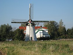
Elkerzee
Elkerzee | |
|---|---|
Hamlet | |
 Wind mill De Lelie | |
| Coordinates: 51°43′28″N 3°50′35″E / 51.72432°N 3.84297°E | |
| Country | Netherlands |
| Province | Zeeland |
| Municipality | Schouwen-Duiveland |
| Time zone | UTC+1 (CET) |
| • Summer (DST) | UTC+2 (CEST) |
| Postal code | 4322[1] |
| Dialing code | 0111[1] |
Elkerzee is a hamlet in the Dutch province of Zeeland. It is a part of the municipality of Schouwen-Duiveland, and lies about 1 km south of Scharendijke.[2]
Elkerzee is not a statistical entity,[3] and the postal authorities have placed it under Scharendijke.[1] It has its own place name signs. It was home to 489 people in 1840. Nowadays it consists of about 10 houses. A church was built in 1741, but was demolished in 1958, because a new church had been built in neighbouring Scharendijke.[4]
The grist mill De Lelie was built in 1868 and decommissioned in 1960. In 2008, it was bought and turned into a restaurant specialising in pan cakes. The flour for the pancakes is ground by the wind mill.[4]
Elkerzee was a separate municipality until 1961, when it was merged into Middenschouwen.[5]
Gallery
[edit]-
Former church of Elkerzee
-
Village view (1920)
References
[edit]- ^ a b c "Postcode 4322 in Scharendijke". Postcode bij adres (in Dutch). Retrieved 21 April 2022.
- ^ ANWB Topografische Atlas Nederland, Topografische Dienst and ANWB, 2005.
- ^ "Kerncijfers wijken en buurten 2021". Central Bureau of Statistics. Retrieved 21 April 2022.
not found
- ^ a b "Elkerzee". Plaatsengids (in Dutch). Retrieved 21 April 2022.
- ^ Ad van der Meer and Onno Boonstra, "Repertorium van Nederlands gemeenten", KNAW, 2006. "KNAW > Publicaties > Detailpagina". Archived from the original on 2007-02-20. Retrieved 2009-12-03.


